
There aren't many people who have discovered the joys of the Owyhee Canyonlands. Nestled in the remote, southeastern corner of Oregon, the roads that crisscross this remote stretch of desert hold many wonderful secrets to explore for those who do venture into the folds of the landscape. Through it all, the Owyhee River runs south-to-north, carving the Grand Canyon of Oregon - thousands of feet down - through the volcanic surface.
Nearly all explorations in Owyhee region start east of the river - that is, after all, where the most well-known landmarks lay. In fact, I know only one person who has ventured west - at least, north of Rome Station - and like everyone else, we've never ever been. Until now.
Keen to find out what the heck was over there, we started our adventure where I'd ended my last trip to Owyhee - at the Pillars of Rome - so @mrs.turbodb could see them as well.

The Pillars of Rome were a bucket list item for us. While they are beautiful, they are a bit underwhelming.
From the Pillars, we headed north. Having already made a 10-hour drive to get here, our destination for the night was a nostalgic one - the place where @mrs.turbodb and I had camped on our first trip together, several years earlier - Chalk Basin.

Headed north.
Just below the surface, the volcanic history of this area is still apparent.
As we wound our way forward, the sun seemed to accelerate toward the horizon. This was fine with us - the colors splayed across the landscape always more dramatic as the long rays pass through the atmosphere. We weren't the only ones enjoying the warm breeze - a herd of wild horses stood tall, taking in the views as well.

Some of the healthiest looking horses we've seen.

Golden rays.
It was only a few more minutes before the sun was below the horizon, its rays now painting the sky above as shadows spread across the ground below.

Pastel splash.
We still had a few more miles to cover before reaching camp, but knowing where it was, we weren't at all worried. Before long we were perched above Chalk Basin, the warm wind whipping at the tent, as we climbed into bed, eager to see what the next two days had in store.

A familiar spot.
The Following Day
Unaware that my phone had synchronized itself with Mountain Time instead of Pacific (Real) Time, my alarm woke us to the pitch black of 4:30am. Disoriented, we wiggled our way down under the covers for another hour of shut-eye before the sun started to make itself known along the horizon.

If the moon is up, it's still night - right?

Silhouette.
Unsure how full our next several days would be, @mrs.turbodb knew I'd want to get an early start. So, rather than climbing back into the tent after a few photos, she climbed down the ladder and got our breakfast going as I put the tent away. And then we had a decision to make - hike Chalk Basin or get on the road to other, new destinations?
Usually we opt for new, but - what with the memories of our previous trip and an idea for an easier route - today we decided that hiking out to Yellow Knoll and Yellow Dome were worth it. We set out across the desert.
Unfortunately, the sun was in exactly the wrong place to capture Chalk Basin - the major features all in deep shadow - but it was nice getting out and walking. We wove our way through the sage to the edge of the canyon before retracing our steps and deciding that we'd take the road down into the basin, since we were here anyway™. 
End of the road. A camp site for the future!

Retracing our steps past Painted Cliffs.
With Chalk Basin behind us, we were officially into the unknown as we headed north on Tub Springs Road. I must admit, I was slightly nervous, for two reasons: first, there is so little information about this area available online that I had no idea if we'd see anything worthwhile. Second, I had no idea what sort of condition the roads were in, and even whether some of them still existed. If there was nothing to see, or if we were constantly backtracking on terrible roads, neither I nor my co-pilot were going to be happy campers.

Oh please let there be something good.
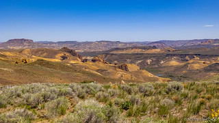
An hour later, we'd seen nothing but the rolling fields. At least they were green - given the time of year - but so far our exploration was best described as bumpy and boring. Then, we came to an overlook. I'd actually marked this on our GPS as a possible camp site, though there was no way it would have worked out timing wise, the night before. Looking down on Chalk Basin, I was reminded that this is how the Owyhee area is - bland on the surface, but with a bit of digging... fantastic!

A grand view of Chalk Basin.
We admired the view for a few minutes before climbing back in the Tacoma and heading back the way we'd come - this was a short spur on an otherwise northerly drive we had planned for the day. It was a drive that would remind us of the Oregon BDR (a Backcountry Discovery Route) - @mrs.turbodb hopping out more often than she'd probably prefer to open gates as we we bumped along poorly graded roads through sagebrush.

Good gate etiquette.
It's not that the landscape wasn't beautiful in spots - it was spring after all. Yellow, pink, red, and purple flowers dotted our surroundings. Green hillsides rose into the distance. Cows pooping everywhere. So yeah, beautiful in spots.

Spring is here!
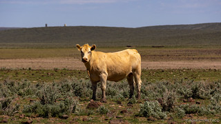
Looking past the poopy exterior, there's a beautiful fillet in there somewhere.
Ultimately, our goal was to make it down to the river. It would be our first time accessing it from the west, and I hoped that we could do so via the ▮▮▮▮▮▮▮▮▮▮▮▮▮▮ . If we could, this would spit us out at an overlook above the Owyhee River Rock Dam, a location I'd hiked to on my previous trip, and that I knew @mrs.turbodb would enjoy.

Our fingers were crossed as we headed down into the canyon.
Alas, it was not to be, the road ending near the old ranch house, which was eagerly explored and quite fascinating.

Home sweet home.

Clearly still in use, at times.

There are many pronghorn in the area, though some luckier than others, apparently.

Look at that rack!
Though presently unoccupied by humans, the ▮▮▮▮▮▮▮▮▮▮▮▮▮▮ was crawling with life - of the cold blooded variety. A fat western fence lizard and extremely bold beetle were only two of the creatures roaming the land. A nearby pond was full of aquatic specimens, and would have been fun to cast into, I'm sure!

That is a 6" wide board this enormous blue bellied lizard is straddling.

If this is a dung beetle, he's in the right spot, fo shizzle.
Exploration of the ranch completed - and with no way to the water - we once again retraced our steps, the road north eventually becoming more of a suggestion than anything official.

We are, I assure you, on the trail.
It was another couple hours - as we made our way along the Turner and Willow Springs Roads - of monotony. As a suggestion, the road here was in tough shape and we rarely reached speeds over 10mph. So little presented itself that we eventually took a photo of the only variance in the landscape.

Look, it's not sagebrush! 
Eventually we once again reached the edge of the canyon and started down to Hole in the Ground. The homestead on the east side was where I'd begun my hike to the rock dam, and it was cool enough that I was excited for @mrs.turbodb to see it, even from the opposite side of the river. For now though, we reveled in the wildflowers that covered the hillside as we began our descent.

A blanket of yellow.
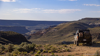
The Owyhee Plateau does an amazing job of hiding the spectacular interior of the canyon until you are right up on it.
Six miles and some 40 minutes later we found ourselves nearing the bottom. Both due to road conditions and the views outside the Tacoma, it was not a fast descent. It was also much warmer here - some 3000' feet lower than we'd started - and we were both hungry. So, rather than drive the remaining couple of miles to Hole in the Ground, we found a lone tree on the river and deployed our chairs in its shade. It was lunch time.

In the distance, red roofs betray the existance of Hole in the Ground.

The perfect spot for lunch.
Our food for this trip was more mundane than our usual easy-but-still-interesting fare. We'd brought only PB&J sandwiches as the main course for lunch, which we scarfed down with potato chips, an apple, and copious amounts of water as the Owyhee River thundered by just a few feet away.
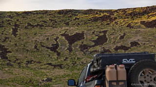
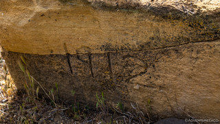
Our stomachs satisfied, I wandered around a bit as @mrs.turbodb got things stowed back into the boxes, and to my delight I stumbled upon a couple rocks covered in petroglyphs! These weren't the elaborate panels we've seen in other locations, but finding them completely by accident was thrilling in itself.

Notice the older glyphs to the left which are nearly invisible due to being re-patinaed.

What does it mean?
We hopped around for several more minutes, our hopes high that we'd find more art. We didn't, and eventually the heat drove us back to the comfort of the Tacoma's A/C as we headed south - upstream - towards Hole in the Ground.

The last couple miles to Hole in the Ground.

From here, the homestead still appears nearly habitable. I assure you, it is not.
As with our first two stops, Hole in the Ground is at the end of a road. Well, in the late summer if the river is low enough, one might be able to ford it in spots and continue up the other side of the canyon, but for anyone staying on the west side - like us - the only way out is to climb back up the canyon wall in order to head north.
And that'd been our plan - as I'd mapped it out - until we noticed a trail that split off from ours and seemed to head down toward Owyhee Road and the old William Griffith Ranch. Actually, we had no idea about the William Griffith as we turned east - I just wanted to get down to a road along the river that appeared to terminate near the Birch Creek Ranch - another spot I'd visited during my more easterly explorations.

Hope this goes through.

Worthwhile views, even if we have to turn around.

We're going to make it!
Once we realized that William Griffith Ranch Road was going to get us to the river, we were quite excited. Where our route previously had required backtracking and a 70-mile out-and-back to reach this spot, our five mile shortcut meant that we stood a chance of making this section of trail into a through-trail, exiting out along the river - if everything went to plan.
Spoiler alert: Never count on everything going to plan.
For now though, we found ourselves at a ranch we'd not even known existed, and we were out of the truck exploring. This was the old Griffith place.

An old dugout, built from quarried stone.
Apparently built around 1912.
An old sign from the U.S. Bureau of Reclamation that we found on site gave us a bit of the history behind this place.
The Griffith family earned a living breeding horses. They also raised cows and grew vegetables. The farmstead contained a stone house, bunk house, shed, stable, stone corrals, and storage cellars. In 1927, the Griffith's 255 acres was purchased by the U.S. Bureau of Reclamation for $6,500 as a buffer for the soon-to-be-constructed Owyhee Reservoir.

State of the art in 1927. Today's ranchers use strikingly similar equipment.

A lot of work went into this place. Imagine the hours it took to chisel each of those blocks.

A stone corral.
It was just after 3:00pm when we headed upstream from the Griffith place towards Birch Creek Ranch. Once again, this was a place I wanted to show off to @mrs.turbodb, and I knew that the geology along this stretch of river was spectacular, which was a bonus. Of course, there was also a little part of me that just wanted to see if the road would go through, if I'm being 100% up front about everything!

Hard to complain about views like this!
Before long, we reached a fork in the road. To our left, a spur led to a river crossing that I knew from my previous visit was impassable - the river was just too high for anyone with any sense to make it through. Were we to have made it, we'd find ourselves at the location I'd camped, and one I'd highly recommend to anyone who finds themselves near Birch Creek Ranch as evening is approaching.

Whites, yellows, and reds abound in the Owyhees.
To our right, the road continued south and in the hopes that we'd catch a glimpse of the ranch and some of the scenery around it, that's the route we followed. Soon however, the already narrow road narrowed further. I stopped the truck to walk a rather narrow section that was likely passable, but that we'd have to back up on if there wasn't a turnaround. It was a good thing too, because it soon became apparent that only ATVs could travel the remainder of this trail - rock slides and erosion taking their toll over the years.
Following the trail on foot, I got as far as the old water wheel before heading back and letting @mrs.turbodb know that we'd reached the end of our trail.

A different perspective (than I'd gotten last time).
It was at this point that we had a decision to make - where we were going to find camp. It was still relatively early - only 3:30pm - but the sweltering temps, long drive the day before, and the bumpy roads had both of us a little tired and grumpy. Yes, we too get grumpy, even in the beauty of nature.
In addition to our grumpiness, the shortcut we'd found meant that we were way ahead of schedule - or so we believed at this point - so there wasn't really any reason to push forward or rush.
And finally, a mile or so back, we'd passed an open meadow with some tremendous views, so I suggested that we find a good spot to camp there and call it a day. In no time, we were set up under some of the most striking cliffs we'd seen all day, and after a quick peek at the river, we climbed into the tent for a much needed nap.

What a lucky spot to find.

The calm before the storm.

Naps are the best, especially somewhere like this.
I think we relaxed for nearly three hours, and boy was it worth it. It was 7:00pm when we finally climbed out of the tent, the temperatures still warm but now more pleasant than oppressing. @mrs.turbodb commented on the ominous clouds in the distance. I reassured her that the weather report was quite clear that no rain was in our future.
Famous last words.
We made taco-rittos - these are, as regular readers may recall, burritos that I call tacos because of how they are folded - out of the back of the truck as the sun continued to settle along the horizon. As it did, the stormy clouds made for some seriously strange light and then suddenly - FLASH, BANG!
Lightning.

"Don't worry, it's not going to rain." -Dan
We watched the lightning dance over the colorful cliffs for a good 30 minutes as the sun streamed in from the west. Yellows and oranges from the sun and ground contrasted spectacularly with the purples and blues in the sky. It was one of the most memorable evenings I've had on the trail.

Nature's fireworks. The best finale.
And then the rain started. Big drops, infrequent at first. I was incredulous and @mrs.turbodb gave me that, "I told you so," look that might also imply a little bit of "you dummy for not listening to me." What can I say but guilty as charged.
In the near distance we could see that the rain was falling harder and faster and making its way toward us. Like rats, we scurried into the tent as the downpour reached camp. With more confidence than I felt, I reassured @mrs.turbodb that this rain wouldn't be a problem at all. Because, you know, it's not like this place is known for completely impassable, muddy, sticky, gooey, clay when the roads get wet.
Oh, wait. But we'd just have to deal with that tomorrow.

As always, great photos and story. The horses are mostly feral horses, the mustangs are dark brown and scraggly looking. The hole in the ground is the old Morcom place, originally from Jordan Valley, Oregon. Jim and Stacy Morcom has lived in Visilia for many years now at an olive ranch.
The trail along the reservoir is almost out of the water, a couple weeks then you can go along the river to Hattie Harrolds place.
Thanks Kenny! I was wondering about all the Morcom stuff in the area. Do they lease out the land now, or have hands that run it for them remotely? Seems we saw a few more places with their name on it (which I have in the next part of the story).
For your readers and followers, the Morcom place sold to the BLM about 25 years ago. Not sure exactly why as the BLM also bought the Birch Creek ranch which is still active. Both places are very interesting to explore around.