
The lightning stopped not long after we climbed into the tent, but the wind picked up and the torrential rain poured down, on-and-off, until about 4:00am. Luckily for us, the downpours never lasted more than a few minutes, and when I climbed down out of the tent around 6:30am, the ground was completely dry, as was the tent.
There would be no muddy roads for us, we were lucky!
The wind had - however - meant that neither of us got a great night sleep, so I wandered off for a hike while @mrs.turbodb got a little more shut eye. Curious about some volcanic pillars we saw at the top of the canyon to the west of camp, I headed up the hillside to get a closer look, our camp shrinking below.

What a perfect spot we'd found!
From below, the palisade looked so well formed - tall pillars stretching toward the sky. Up close however, they were much harder to make out - appearing almost as a jumble of rocks, rather than the columns of basalt that they were. Still, they contained many nooks and cranies, now the homes of countless desert animals, so were an interesting destination to be sure.

Much less uniform up close.
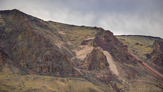
And, across the canyon, I spotted something equally intriguing - at least, for someone such as myself  . A road I'd gotten wind of after one of my previous excursions on the east side, but hadn't yet had a chance to investigate beyond Google Earth - the road to the Christine Marie Mine!
Looks legit.
A little less sure that I wanted to drive that road solo now that I'd seen it, I headed back to camp to find @mrs.turbodb already prepping breakfast. I asked her if she'd seen me up on the hillside, and she just laughed a bit as she looked at my clothing: camo cargo pants and a light grey sweatshirt. I was hard to see even 50 feet away!

Even cloudy, my return to camp was awesome.
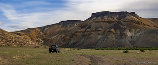
By the time we ate breakfast and put away camp, it was nearly 9:00am when we finally headed north on Owyhee Road. It was a couple hours later than our usual departure time, but the relaxed morning was a nice indulgence and the fact that we'd found a shortcut the previous day meant that we were feeling good about our schedule today.
Headed out, under a bluing sky.
Back past the William Griffith Ranch, we stopped for a quick investigation of the thatched shed - a structure I'd somehow neglected to investigate the previous afteroon. It was amazing to me that it'd held up so well after all these years - remember, this ranch was purchased (and last used) in 1927.

Aged well.
With that, we continued north, our fingers crossed that Owyhee Road would continue along the bank of the river for some 20 miles or more - past the Morcom Ranch and eventually out past the Owyhee Reservoir.

A more interesting route than the monochromatic green of the plateau.

We discovered many geodetic markers over the course of this trip, likely - as @mrs.turbodb suggested - the result of surveys for the Owyhee Reservoir.
Initially several hundred feet from the river in a wider portion of the canyon, the road was soon squeezed between the narrowing canyon walls and the rushing water below. On the uphill side, orange outcroppings rose high in the air, contrasting fabulously with the sky and clouds.
Is this considered an arch?
And then, as we turned a corner - and perhaps only a couple miles into our day's journey - I stopped the Tacoma and looked over at my copilot. "I think I'm going to walk this," I said - the road narrowing as the scree field encroached upon it, and erosion continued to eat away at the downhill side.
As I did, the first hundred feet or so were passable. I'd initially been worried about a large boulder that'd rolled down the hill and blocked part of the road, but I was pretty sure that with careful tire placement, I could climb up and over it in order to continue on. It was further - a thousand feet or so ahead - that I realized was going to force us to retrace our steps all the way out of the canyon. Here, the road was nothing more than a hiking trail - even an ATV would have difficulty on this section now.

I am standing in the "road," which skirts just to the left of the point of rock. At 30" wide, I don't think the Tacoma is going to make it.
As I walked back to the truck I couldn't help but feel a little deflated. All that time we'd saved in finding this route was lost - our only option now to climb back to the rim of the canyon. Still, looking back now, it's important to rememeber how lucky we were that the rain didn't leave the roads impassable, or we might have found ourselves confined to the area for a couple days while things dried out!

Gaining elevation on our way out. Views of Red Bluff.

Our route may have been longer, but it wasn't without its highlights.

Cheer up, explorers, it's spring!
Eventually we were back on the plateau and making our way along road that were - thankfully - better than the day before. As we stopped for one of the many gates, I took a closer look at my offline maps and discovered a road that might allow us another shortcut if it went through. Thing was, the maps appeared to show two roads that nearly went through, but were connected by a short segment of questionable trail.
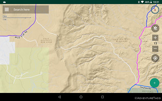
Can't hurt to give it a try. Not like it appears to drop off a cliff or anything based on the topo lines. 
Hopefully this route would once again save us a good number of miles and a couple hours of daylight, dropping us down to Owyhee Road, just a few miles north of the impassable segment where we'd been forced to turn around. A final gate was all that stood between us and ... the hope that the trail went through!

Perched on the edge.
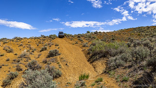
Initially steep, the road plunged down the canyon wall. The elements had taken a toll here - ruts deep along the narrow trail. As with other narrow sections, I'd gotten out to walk part of this one before proceeding, but the road was so steep that I'd only scouted to a location where I felt I could turn around if neccesary, hoping that once we made it to that point, we'd be able to see the rest of the trail.
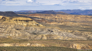
To our north and west, the Owyhee Badlands stretched out before us.
Watching the GPS as closely as the road, I think we were both a little relieved when we realized that we were going to make it - the roads did connect! Smiles on our faces, we continued down toward Red Butte and the bottom of the canyon.

Red Butte, looking at little green in the spring.

Though the road was easily passable for us, it wasn't without its...interesting spots for others. We found numerous car parts along the way.
By 12:30pm, we'd reached Owyhee Road as it snaked its way alongside the river. Morcom Ranch was less than a mile to our south, and as we headed that direction, there was no push-back when I suggested that perhaps we should eat lunch once we arrived.
You see, I'd assumed that Morcom Ranch would be like the others we'd run into so far this trip - either well maintained, or at the very least interesting from a historical perspective. It was, neither.

Only a shed of a house remains.

Tacky.
As we pulled up, the reason for the condition of the place was already obvious: this spot was clearly trafficked by orders of magnitude more people than anywhere else we'd been so far. The roads were well graded, and like many areas under the juristiction of the BLM, UTV owners had obviously felt the need to climb every hill and cut every corner - there were tracks everywhere.
So, it was back into the Tacoma and we headed further south - to find a spot on the river that was a tad more to our liking and to see how far north the morning's segment of impassable trail extended.
We found our lunch spot, first.

More our style.
With the partly sunny skies, lunch was a much more pleasant affair than it'd been the day before in 90+°F heat. We ate our sandwiches and chips to the chirping of swallows as they flew in and out of their mud nests on the opposite shore.
We found the end of the road about a mile further upstream, where it once again got narrow and became an ATV trail before a single-track path. In all, probabably only a quarter- to half-mile was impassable, but it was enough.

We passed a dugout - more like a bunker - on our way to the end of the road.

Dramatic ending.
Ultimately, as I walked the narrow section, I realized that this impassable stretch was a blessing. The ranches, petroglyphs, and peacefully pristine meadows we'd visited the day before would surely have been overrun - as was Morcom Ranch - had the road gone through. What I'd thought of as misfortuned at the time we'd turned around was itself, a little lucky!
A smile on my face, I headed back to the Tacoma and we set off to the north. We were once again way ahead of schedule, so a couple stops along the way - first for an old hay baler, then for a nice shot of Red Butte - were no problem at all.

Memories of decades past.
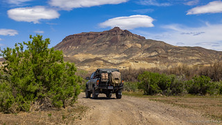
Red Butte dominated the landscape.
For the next several miles, we'd follow Dry Creek Road as it wound north between Red Butte and the Owyhee Badlands. Our ultimate destination was Red Butte Canyon, and I'd hoped that we could take a back route into the area - that is, if the trail still existed.
It didn't, but I'd suspected that to be the case when I'd traced the route in Google Earth, and so had planned an alternate route. It was slightly longer and would require a bit of out-and-back, but it would get us where we were going, and that's all that really mattered.
Plus, it turns out that as we headed out to ▮▮▮▮▮▮▮▮▮▮▮▮▮▮▮ and ultimately Red Butte Canyon via this route, the grassy landscape was extremely pleasant - surely nicer than the faded, rocky, road that I'd planned originally.

A carefully cowfully manicured meadow.
We arrived at ▮▮▮▮▮▮▮▮▮▮▮▮▮▮▮ right around 2:30pm, and though there were signs of recent habitation, a notebook with a log of days spent in the cabin clearly indicated that no one was currently on-site. Like the ▮▮▮▮▮▮▮▮▮▮▮▮▮▮ , this cabin was in great shape - and we looked around for only a short time, as respectfully as possible.

The sight that welcomed us. It seems there are always lots of matress springs, no matter where we go. Some of the OSB used for the walls of this cabin were stamped with a date less than 9 months old.

Quite a nice little place, but could use a cow or two - to manicure the lawn.

We saw several cows on this trip - some as many as 75 miles south - that bore this brand.

Well, that explains the bed frames and springs. A nice setup.

Seemed to be working, and we were careful to do our part.

Back to our trusty steed.
From the cabin, it was but a few miles to Red Butte Canyon and the end of the road - at the top of a steep descent into the canyon. We dismounted and grabbed our water, and set off down the path to see if the interesting landscape I'd found in satelite imagery translated to something worthwhile on the ground.
Yes, I left it in gear as we walked away.
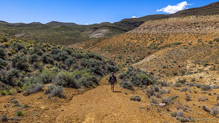
Nice to be on foot, headed into the canyon.
It turns out there wasn't much in Red Butte Canyon. At the time, I kicked myself a bit for not doing a bit more research to better understand the "point" of the road that led to this spot. Perhaps if we walked a little further, or turned up a fold in the badlands, or knew where to look for some special stone... Perhaps then, I thought, a view or motherlode would reveal itself, and we would have our answer.
However, upon returning to civilization, I had another look at the satelite. It turns out that there wasn't - as far as I can tell - some magical place we were suppossed to find. Rather, we were in the middle of the magic, our perspective at the bottom of the canyon such that we couldn't fully realize what was better seen from the air.
Not that the view on the ground was all bad either!

Rainbow of paintbrush.
So, it was a short hike - maybe 30 minutes or so - before we were back in the Tacoma, once again glad for the A/C as the afternoon sun beat down on the terrain. We'd covered nearly everything I'd planned, and it was time to make a decision: should we head out to the west - eventually exiting the Owyhee's near Harper, or venture onward to the north - looking for a route that connected to another set of trails I'd assumed we wouldn't have time for on this trip?
So far ahead of schedule - and with plenty of fuel - the unknown route to the north won out, and after a short detour to Eddy's Place (historical) and Cow Creek Spring, we turned north.
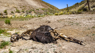
All we found at Eddy's Place and Cow Creek Spring. Its left front leg burried in mud up to its chest, it was unable to free itself; then nature took over.
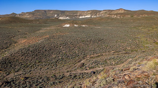
It turns out that the trip north was significantly easier than we'd expected. Deadmans Gulch and then Twin Spring Road were nicely graded and heavily travelled. The views weren't as great as those we'd had next to the river, but they were still much more interesting than the top of the plateau.

Much more pleasant travel when the road is more than a suggestion.

Life blood of the desert, not long for this world.
Right around 5:00pm, we found ourselves - according to a BLM sign - 28 miles from Nyssa, at a spot with a nice view of Red Butte. Having enjoyed our early arrival in camp the afternoon before, I suggested we do the same this evening, though ideally without the rain. There was no argument from the passenger seat, and we set about setting up.
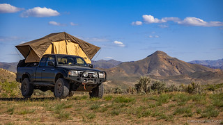
Well then, that's nice.
Much as we had the evening before, a nap preceeded dinner, and as the sun was casting longer and longer rays over the landscape, we munched on taco-rritos in the wind shadow of the tent.

Late afternoon.
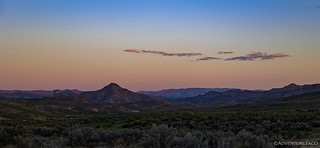
Early evening.
Tired from our naps and stuffing our faces with food, the only thing left to do was crawl into bed before the last of the evening light left the sky. As wind battered the tent - it was one of the windiest nights we've had in a long while - we drifted off to sleep.
The Last Day
I was up at 6:30am, and @mrs.turbodb was up not long after. Where we'd lazied around a bit the previous morning, we had no such luxury on this - the last day of our trip. Not only did we want to make it all the way home, but we wanted to check out one final place I'd marked on my maps.

But for the direction of shadows, strikingly similar to late afternoon.
Continuing north on Twin Spring Road, an interesting outcropping pierced the rolling hills to our west. Zooming in on the tablet, @mrs.turbodb found the name - Negro Rock - and I couldn't believe it. I'd stumbled on Negro Rock in my pre-trip research as an interesting place to visit, but I'd never been able to pinpoint it on a map. And then here we were, driving right by!

Negro Rock, marked for future exploration.
Not long after, we approached our morning's destination - Haystack Rock - from the north. Rockhounds love this place - for the jasper and agates that can sometimes be found, but we were here solely for the views.

Aptly named, I'd say.

The sides are steeper than they appear.
Navigating our way to the base of the mountain, I hadn't planned to summit Haystack Rock until we got out of the truck and I took my first look up. At that point, the challenge was on as I searched for - and eventually found - a route to the top.
I bet there's a great camp site out there for next time.
And with that, we made our way down - always a sketchier proposition than climbing up, it seems - and followed Mitchell Butte Road to pavement and the sleepy little town of Nyssa.

Back to civilization.
Like many, this trip didn't go entirely as planned - but as often seems to be the case, there's always reason to return!

Another great adventurous day exploring some of the most beautiful country in the west. The Owyhees are my most favorite place to explore, thanks for sharing.
We stumbled upon that cabin on one of our dualsport trips in 2018. Glad to see it is still in good shape. There were only 4 beds in that area then. Thanks for the write up
nate
Very cool. Ive wanted to check out the west side. Crayz that lil quarter mile section looks doable on google.
ONCE AGAIN, THANKS FOR THE TRIP TO HEAVEN. YESTERDAY WAS A ROUGH DAY FOR ME AND I CAME ALONG ON THIS TRIP W/ YALL JUST TO SETTLE MY MOOD AND GET A TASTE OF NATURE. I WAS NOT DISAPPOINTED. I WISH I WAS AT LEAST 20 YRS YOUNGER SO I'D HAVE TIME TO SEE IT ALL. LOL VERY ENJOYABLE AND I FEEL MUCH BETTER NOW. THX GUYS. JEANNIE
Your comment brought a smile to my face Jeannie. I'm glad you enjoyed the story, and hope you can come along for future adventures as well!
Followed along with you on Google Earth. I know this area pretty well just by map. I have been, like you said, all over the east side. I was planning a trip this year into this area when I stumbled upon this blog.
I have been into the Watson area, what you called the Morcom Ranch in this blog, a couple of times. Not sure it there are two Morcom Ranches? The Hole In The Ground Ranch is also known as the Morcom Ranch.
This gives me some good recon for the area. I usually have others traveling with me and often it is good to know road conditions for different skill levels. Looks like most were pretty straight forward.
I agree the ATV, Side By Side group are going to kill these areas in another few years. Visit them while you still can. Tread lightly and take only pictures.
If interested, you can check out my Youtube Channel.
See you on the trails! George.
Hey George, glad you found the stories and were able to follow along - always nice to find someone else who really enjoys the Owyhee area (in any of the three states it covers)!
The roads on the east side are quite comparable to those on the west - mostly pretty straight forward, with the odd technical section here and there. The west side is a bit more remote (since there are fewer people there and fuel is even further away, but it's the same beautiful countryside for the most part. And - as you likely know - there are several river crossings that connect the two sides, but since it's usually a spring exploration area for me, I've never been there when the water has been low enough. (I noticed you mentioned the disappearing road in a quick skim of one of your YT videos. ?)
As for the Morcom's - my understanding, from talking to locals who know a lot more than I do - is that they were all over the place. Hole in the Ground was one of their main ranches, but they had Cow Camps in several places, and even a ranch houses sprinkled here and there. Much like the Mackenzies, if you've been to any of their places.
Speaking of Mackenzies, I found a copy of Owyhee Grafitti Vol 1 in one of their cabins. It's certainly not for everyone, but I found it to be a fun read that gave a lot of interesting background on the Owyhees.
Have fun and stay safe out there. Would love to hear what route you come up with, and then after you go, I'd certainly watch the videos/series! ?
Thanks for the reply. Good to know on the roads. My main concern was the road heading down into the canyon. I knew about the road that is washed out along the river. Can't tell you how many times I heard about backing out of that section of road from the north.
The disappearing road is a fun road to drive. I call it the disappearing road because usually it is underwater. With the drier weather the last few years it has opened up again. I usually keep my eye on the water level since my first trip in 5 years ago. Last year was the first year it was exposed again. Before the dam was built there was a road that ran up the canyon to these places. There are remains of some ranches that are usually underwater back there. I have visited the old Watson Post Office which is underwater when the lake is full and not too far from the Morcom Ranch you reference in this blog. Pretty cool area for sure.
I have not read that book, but I do recommend Sage Brush Post Offices by Mildretta Adams. If they still have the book you can get it here a lot cheaper than other places online http://www.owyheepublishing.com/books.php . I am following along on some of your other trips.
Maybe we will someday bump into each other on the trails. George.
Hey George, I always try to reply to every comment - I know how much I like to hear back when I comment on other explorer's stories!
The road down to the creek is just fine - a little steep in places, and there are a couple forks that I recall not matching what I'd mapped prior to heading out, but it was pretty obvious once I was on the ground.
And, for the hidden road, I know exactly the road that you're referring to, and it's on-again/off-again nature. I have a "buddy" (who I've never met, but who I've had hours and hours of conversation with about Owyhee) who has used the hidden road to access a lot of the places - homesteads, hot springs, rock art, etc. up the river for more than 50 years now. He's both worked and explored the area, and lived in Arock (married a woman who'd grown up there).
I'm definitely going to check out the Sage Brush Post Offices, sounds like it might be right up my alley. And, I don't know if you've stumbled on my link to this as you've read through some of the stories, but there is another blog that I archived because I thought it was so cool - Mining Morrisonite. A firsthand retelling of working the Christine Marie Mine. It is both incomplete and fantastic.
Like you, I hope that we cross paths as we're out on the trails - I always enjoy putting faces to names, and sharing in vast landscapes that are mutually enjoyed.
Thanks for the link. That was a good read. Oddly I think I have read part of that before.
Yes, always good to find fellow adventurers that share like interests. I subscribed so I will be following along on your adventures. George.
I was just rereading this blog since my trip into this area is next weekend. This time I realized you had missed the road I planned to take. When you went north till you realized the road was unpassable you had to back track to the top of the canyon. For some reason I thought you had taken the road shortly before the canyon rim when I read it the first time. Not sure if you noticed that road or not. It basically starts just below the canyon rim and then rejoins the road along the river about where you stopped for lunch later that day. The road does not show up on Google earth. You have to look for it, but it looks to be a good road.
I use google earth and acme map for route planning. Google earth is a good reference but often I find roads that really are not there even though it maps it out as a road. Then there are the roads that are there, like this one, that they do not even mark as a road. I find this especially true in these remote areas. Often where you need the most accurate information.
Well, I'll give a report of my findings when I get back. Stay safe! George.
Hey George, so, I'm not quite sure about the road you're talking about, but there is no road that "directly" bypasses that short section of impassable trail. Rather, the "best/only" way around are a couple of river crossings that take you to a road (and other interesting destinations ?) on the other side. The "problem" of course is that this time of year, there's way too much water in the river to cross. At least, usually.
Feel free to email me if you'd like to discuss specific roads; happy to do so. You can start the email from this notification, or using the https://adventuretaco.com/contact page.
And of course, I'd love to hear how your trip was when you return - I haven't made it down to Owyhee yet this year, but it's getting to be the "time of green" so I'll probably try to get down there soon! ?