
Our location at the Kelso Dunes was the first where I thought there'd be a chance of a nice sunrise, so I'd set my alarm for 6:00am to try and catch the orange on the horizon. It was of course quite chilly at 6:00am, and so I had the bright idea to just take a photo with my phone out the door of the tent, rather than climbing down the ladder to fetch the Canon 80D - that I shoot with - from the truck.
Well, the photo came out so poorly - compared to what I'm now used to - that I'm not even going to share it. But hey, I stayed warm and got another hour of sleep! 
As the sun crested the horizon - or at least our horizon for the morning - we did finally pull ourselves out of bed, happy to see that the breeze we'd had during the night was successful in keeping the tent totally dry. And waking up to the illuminated dunes and Devil's Playground wasn't anything to complain about!


Not having to wait for anything to dry out, we made quick work of breakfast and camp tear-down, and we were soon on the road and headed south. Our goal for the day was twofold - visit cool places, and stay out of the snow (if possible). Our first cool place - Hidden Hill, home to the Hidden Hill Mine and Golden Queen Mine - was between 3300' - 3950', so we knew it'd be a good indicator for the remainder of the day, where we'd be spending some time between 4000' - 4700'.
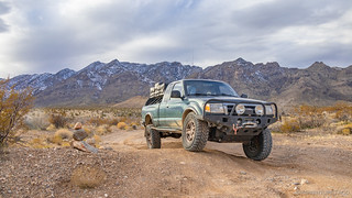
Hidden Hill Road is accessible from Kelbaker road, just south of Granite Pass, which afforded us an amazing view of the Granite Mountains, still very snow-covered from the storm a few days earlier. Even with a full day in front of us, we spent a bit of time soaking in the views here - first in front of us, and then in our mirrors as we made our way east.
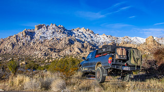
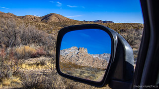
It's probably worth mentioning here - and maybe a few other places in this series of stories - that the roads in the Mojave National Preserve are generally in amazingly good condition. As I recall, we were still aired up at this point, and only aired down a couple times throughout the entire trip as we encountered individually rough roads, or wanted to increase our speed. At any rate, heading east, we had a few miles to travel towards the south end of the Providence Mountains before we came to an old windmill that marked the entrance to the Hidden Hill area.


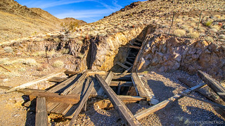
The first mine we came to - a quarter mile or so further up the road - was the Golden Queen Mine. With one of the best-preserved mills in the area, it allowed us to see the path through witch ore flowed better than any other we'd encounter on the trip. Ore was loaded into the wooden hopper at the top of the mill and then fed down into a crusher (which is now gone). After being crushed, it would enter the triangular funnel to be fed into a horizontal cone-shaped ball mill at the next level of concrete foundation. After being further pulverized, it would drop into the final level of partitioned concrete vats, where the gold was separated from the rest of the ore using cyanide.
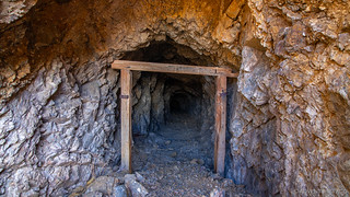
And, next to the mill are two large mine shafts and their associated tailings piles - all of it dating from the early 1900s.


A view of the concrete foundations and vats, where cyanide was used to separate gold from the ore.

An old ball mill.
The Golden Queen's main mine shaft.
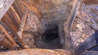

Looks legit. Safety was clearly the first priority here.
After exploring the Golden Queen mine and its shafts for a good half hour or so, it was time to check out the rest of what Hidden Hill had to offer - namely, the workings of the similarly named Hidden Hill Mine. Worked around the same time as the Golden Queen, the hiking trail starts from the Golden Queen's mill and works its way up the face of Hidden Hill to the north. This hiking trail was at one time a mining road, and while it still seemed like it could be drivable, there were two metal fence posts placed to block the way, which should be respected. Regardless, the hike passes by so many mine workings that walking is likely as fast as driving, so we were happy to set out on foot, the barrel cactus and yucca covering the hillside in a beautiful display of color.


It seemed that every 50 feet or so we were stopping to investigate another working. Some were deep mine shafts, others were simple diggings. Still others appeared to be road cuts or ore chutes that material would be sent down in order to reach the mill. Wandering from working to working, we thoroughly enjoyed ourselves - this set of mines being one of our favorite even after visiting many more over the remainder of the trip.

Remains of mine shaft reinforcements, now scattered down the slopes of Hidden Hill.

An old mine shaft, ready to be investigated!

The view out of the old mine shaft, @mrs.turbodb making sure I'm OK.

Inside the same old mine shaft - the intricate tunnel systems evident even in the first 50' of the shaft.
Having completed our investigation, we made our way back down to the Tacoma - itself framed by views of the Clipper Valley to the south. And, as though we hadn't seen enough already, we discovered a new shaft on our way down, ripe for the exploring.

A shaft from the Golden Queen Mine that I'd missed the first time around.

Having gotten an early start, it was still reasonably early in the day - perhaps 10:15am or so when we pulled out of Hidden Hill and towards our next destination - Fenner. See, with the original route I'd planned - essentially a single loop through the preserve - a full tank of gas plus 11 gallons in our (awesome) military Jerry Cans would have been just enough to get us through. But our current route had us doing two loops, and I knew that even though we hadn't tapped into our extra fuel yet, it wouldn't be quite enough to get us through.
But, as we pointed the truck southeast, I just happened to see something out of the corner of my eye to the north. I wondered out loud to my navigator about what it could be, and she made a quick pass through Hiking the Mojave Desert, and discovered that it was in fact another abandoned mine - the Big Horn Mine. A quick conversation later, and we were on our way on an unplanned detour - the best kind of exploring, really.

The Big Horn Mine, it turns out, was a very successful property. Loaded with gold, silver, lead, and copper, the first shafts were sunk in 1895 and mining continued here on-and-off until 1943. Profitable nearly the entire time, its most successful shafts yielded quartz-gold veins 14 inches wide and worth over $500/ton in gold alone. That's over $5,000/ton in 2020 - ground hundreds of times richer than many of the best mines today.
As we reached what we'd seen from a distance - an old (yet newer than the mines) white house - we decided to check it out before continuing across the wash to explore the mine itself. The house was in reasonably good shape, clearly loved by several over the last few years, and a cabin that should be respected by any visitors. Outside, an old tow truck, full of holes from people with no sense of respect, overlooks the valley.


A 16-leaf, "double-stacked-leaf-pack." When comfort is priority 53.
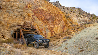
Our cabin exploration complete, we headed to the mine at the rear of the claim. The road, while requiring HC 4WD, was still in reasonable shape and we were able to drive a loop up one side and down the other of the mountain - the inside of which is quite clearly a hollow maze of mine shafts that provided a not-so-small fortune in ore for its owners.

The foundation for an old gold mill, and the fallen 80-foot wooden headframe of the Contention Shaft.

Two 55,000 gallon water tanks that have seen better days.

The Contention Shaft, covered with rusted grating by the National Park Service, had an opening 12-feet square and extends down through more than 600-feet of tunnels.

Another shaft, cut into the Contention Shaft complex and covered by steel cable. I so wanted to lay on that cable, but refrained for safety sake.
The Big Horn Mine exploration complete, it was time to resume our trek to Fenner for fuel. Some 25 miles away at this point, the road was long, straight, and boring as could be as it crossed the alluvial fan and Fenner Valley. We'd aired down by this point - having done so, as I recall, as we made our way to the Big Horn Mine - which allowed us to travel at 30mph or so. As such, it was lunch time when we arrived at what the owners called "The Route 66 Oasis," and we called "Highway Robbery."


With prices like that, we got only as much fuel as I thought we'd need - 5 gallons - and had a quick lunch in the picnic area, before turning tail and heading back towards the preserve - the snow from the recent storm offering a view that not many get to experience.
As we headed north on Essex Road, our ultimate goal for the evening was Hole in the Wall, but before that we hoped we'd be able to squeeze in a hike to the Silver King Mine, and an auto-tour of the Bonanza King Mine and nearby ghost town of Providence. If we could, it would be one of our most fully-packed days so far! Indications were good as we turned off onto Ranch Road - a private road that is extremely well maintained, and that allows easement access to the area we hoped to explore.

Before long and after speeds upwards of 50mph, we found ourselves turning off of Ranch Road and at the wilderness sign that signaled the start of our hike to the Silver King Mine. A couple miles round trip into the foothills of the Providence Mountains, the hike up the wash is a pleasant one, and halfway to the mine we came upon what were once two "twin" cabins, one of which has now collapsed - time and weather taking their toll on the simple sheet metal construction.


Further up the wash as we neared the mine shafts, I found the remnants of a quarried rock building one of the more interesting - and unique - things that we'd see in our explorations. The sheer amount of work that must have gone into quarrying and then shaping these enormous stones is unfathomable - even if the building was, as it appears, never completed.

Shortly thereafter we found ourselves at the Silver King Mine shafts, all of them unprotected by any sort of fencing or screening, a good indication of the low levels of travel that these mines see compared to others in the preserve.


One of the tunnels was accessed via a weathered gangplank that made its way across a deep shaft. Safety first!
And, like many of the mines we'd see on these trips, the views from the Silver King Mine of the sprawling valley below were spectacular even under overcast skies. We took our time walking back to the truck, making an unexpected discovery along the way.

Unexpected. Unspent and left laying around in the desert. Sigh.
From the Silver King, the Bonanza King Mine would have been easily walkable. With a bit more time, I'd recommend making a loop hike out of the two mines, rather than driving - doing so would allow more time to take in the surroundings, and the elevation gain of the entire walk would be minimal. We however only had a couple more hours of light and were unsure at this point where we were going to camp for the night, so pointed the truck towards the Bonanza King and pushed forward.

With more than 20 workings, the Bonanza King Mine extends for several miles along the East Providence Fault Zone at the base of the Providence Mountains. Of these workings, there are two that I would recommend checking out in detail. The first is the main mine shaft. This thing is huge - literally truck-size - and extends deep into the mountain side. With such a wide mouth, plenty of light spills in, and we were able to make our way several hundred feet down the tunnel (walking) before turning around - a much different experience than most other mines we visited. And, regardless of weather, this is always an interesting experience - for us, the ~55°F air was warm and inviting. During summer, the same temperature would surely be welcome relief from the suns hot rays.

The second interesting bit of history here is the old stamp mill built on the side of the mountain. While it's falling apart before our eyes, it is still one of the preserve's best examples of a mill - most of the others removed as part of decommissioning a mine. If you should visit, take some time to walk around the ruins, but be careful to stay off the actual debris - by doing so you will help to preserve it for future visitors.

Just around the corner from the Bonanza King Mine is the ghost town of Providence. Not much of this town - which shares the same name as the mountains in which it resides - remains, but it was once bustling with activity from the surrounding mines. As at the Silver King Mine, the buildings here were built from quarried stone, and as of this writing it is clear that someone is in the process of restoring - or at least reinforcing what is left of - the last of the standing walls.


With that, we'd completed our last set of mines for the day, and stretched the Tacoma's legs a bit on our way out to our next destination - Hole in the Wall - nearly 20 miles north and 1500' higher in elevation.
Now, Hole in the Wall was a place we'd visited on our last trip along the Mojave Road, but at that time it had been raining, and we'd been unable to explore it as much as we'd hoped. Specifically, I was interested in doing the Ring Loop hike, and also in checking out the petroglyphs that I had heard were nearby. As often seems to be the case, we pulled into the parking area and made ourselves at home next to another Tacoma.

And with that, we set off on the Ring Loop hike. This is a mile-or-so long trail around a honeycombed mesa that is highlighted by a short slot canyon where stainless steel rings have been bored into two dry falls in order to make them climbable for hikers. Hiking the trail in a counter-clockwise direction, that meant we'd be climbing down the rings - fun, but I think I'd do it the other way next time.

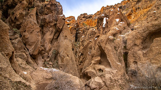


After making our way through the slot canyon, the walls opened up to a honeycombed amphitheater, where we'd later hear a pack of coyotes howling to themselves, their echos carrying on into the night. But for now, we paused along our route to explore the sheer walls with our eyes, finding interesting holes and formations everywhere we looked.


Our remaining daylight limited, we continued around the remaining three quarters of the hike, discovering along the way the petroglyphs that had eluded us previously. Less spectacular than some we've seen in Death Valley National Park to the north and Anza-Borrego Desert State Park to the south, we were still glad to have found them, if only to say we had!


Soon enough we found ourselves back at the parking lot, just as the sun dipped below the clouds, a brilliant splash of orange perfectly painting the geologically striped Woods Mountains to our east for no more than 30 seconds or so!

While on the Ring Loop hike, we'd spotted an ideal spot for camping just to the south of Hole in the Wall, and we made our way that direction so we could get setup and start dinner before the sun set completely. It was perfect timing as it turned out, a break in the clouds along the horizon providing an amazing show for us as the sun lit the sky from below. Combined with the snow-capped mountains, and tasty grilled hot dogs, it was a great way to end another fun day in the Mojave Preserve.


Here, we were at a little over 4000 feet - so we braced ourselves for cold as we climbed into bed. As with the days before, we'd squeaked by with minimal snow, and hoped that the locations we'd planned for the following day would be free of the white stuff by the time we got there. It was a pipe dream really, because we were headed to 6000 feet. Little did we know the excitement that would provide!
The Whole Story


")

")


")

")
")


")
")
")

")


