
Hoping to catch the stars as they danced through the sky, you may recall that I'd setup the camera to take as many 30 second exposures as it could, until its battery ran out, through the cold night. As morning rolled around, I grabbed a second camera battery and popped out of the tent into the 21°F weather to take a look.
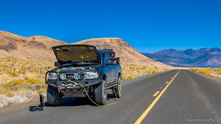
...Only to discover that my second battery was also dead - I'd forgotten to charge it before the trip!  So I plugged in the my little 175W inverter and let a battery charge for an hour. As a side note, I should say that I really like this inverter. Plenty of power for charging camera batteries and my laptop, and no cooling fan so it's completely quiet. I won't be running any hair dryers with it, but that's just fine with me.
Battery charged and another hour of warmth for me, I finally had a chance to check out the previous nights display. Not. Too. Shabby. At all.

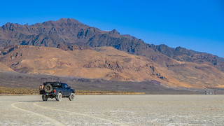
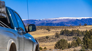
It was a great start to the day, and with the sun now up and warming the playa to a blistering 26°F, we found ourselves out of the tent attempting to eat a bowl of cereal before it froze.  Moving quickly so we could climb in the heated truck, we were soon on our way - a quick stop for a photo of our so-close-but-so-far destination before we headed south to start the ascent up to the highest road in Oregon.
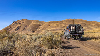
Now, as one should always do, I'd done my best to plan an all-dirt route from the Alvord Playa to the top of Steens Mountain. Most of the land around each - since they are essentially next to each other - is a sprinkling of BLM and private land. And usually that's not a problem - ranchers are generally pretty good, at least in these parts, of leaving gates unlocked and relying on responsible use - closing gates that you open, etc.
So, as we headed off the main drag an onto our first road onto the mountain along Carlson Creek, we were glad to see that while there was a gate, it was unlocked and a sign posted by the BLM noted the various allowed uses - driving included. So we drove through, aired down, and were on our way...
Apparently however, that "driving" was only for the first mile - at which point a locked gate across the road and a smaller opening for hikers and hunters. Well shoot.

Now, a mile or two out of our way is nothing to be concerned with - generally. So we took a look at our offline map and planned route - and noted that just a couple miles down the main road there was another entrance to the mountain...which eventually rejoined the road we'd planned to take up Carlson Creek. And so with that, we were off to Bone Creek and attempt #2 at summiting the highest road in the state.
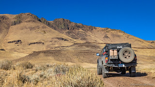
Where we were almost immediately turned around on Carlson Creek, Bone Creek was just the opposite and we continued to climb up into the hills for several miles, marveling at our ability to adapt, patting ourselves on the back. We were - you might say - counting our chickens.
And that seemed to be working just fine. We passed through several gates - some of them open and some not - without incident, none of them locked. We rejoined the original road/route about six miles in and then turned up towards the top of the first ridge we'd climb on our way to Steens. We summited that ridge and took in the views back towards the playa.

And then, our chickens bit back. Not 100 yards down the west side of the ridge - a locked gate for the Roaring Springs Ranch. The bummer was that the sign had a note that hunting (and thus travel) was sometimes allowed via written permission - which may have come with a key - but I'd not contacted them prior to the trip, so we were keyless, and now another hour+ behind schedule.

That's just part of the adventure though, so we turned around and headed back down. This had been our last hope of reaching Steens Mountain Loop on dirt, so it was time to air up, grab some fuel at Fields Station, and use the skinny pedal liberally to try and make up a bit of time.
My liberal use of the skinny pedal is apparently different than most, and so it was a little after 12:30pm when we finally arrived at Steens Mountain Loop and started up in earnest. We were both hungry at this point, and so only a few stops were made over the next 20 miles - for some wild horses and our first view of the snowy summit - just so we could put a few miles behind us before we stopped again!


Now, about 20 miles up the south side of the loop, there's a turn-off. This leads to the Riddle Brothers Ranch, and was something I'd thought we should do when I planned the trip. @mrs.turbodb had come to the same conclusion when reading her book - 100 Hikes / Travel Guide: Eastern Oregon - and we were glad to hear that it was open "from mid-June through October." It was October 12, so that was perfect.
Except that "through October" at the Riddle Brothers Ranch actually means "not through October," because a little more than a mile from the ranch, the gate was closed! We were batting 1.000 on the locked gates, that's for sure.
Luckily in this case there were plenty of signs inviting us to walk around and make the two-mile roundtrip on foot, so we ate a quick lunch and then got underway.
Almost immediately, we saw the first cabin. It belonged to Ben Riddle - the youngest of the bunch - who arrived in 1896 to make the ranch his home. His brothers - Walt and Fred - followed a few years later and worked the land, producing 150 tons of hay each year which was sold along with mules and horses to the U.S. Cavalry for WWI.


Though he was the youngest, Ben also was the first to die - of suicide in 1915 - after several bouts with depression. His brother Fred would continue to ranch the land until he was 82 (in 1952), the livestock changing from mules and horses to cattle after The War.
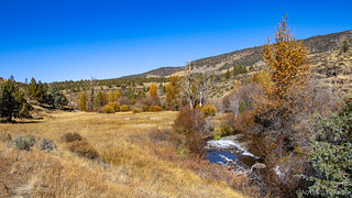
We continued down the Little Blitzen River towards Fred's house and the main ranch complex, the river a constant gurgle to our north, ice starting to creep further from its banks.
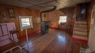
If Ben's cabin had been tiny and isolated, Fred's was anything but. Nicely constructed, he had several outbuildings, including a guest house, tack shop, and large barn - all of them in reasonably good condition now that the BLM has acquired the ranch and preserved much of what was left.
We took our time exploring.

A screened porch and small guest house made for some nice livin'.


Table's set for the next meal in a reasonably well appointed kitchen.

Anyone looking for some nice tunes out on the farm?


The oldest drill press I've ever seen. Still worked great!
Eventually though we knew we had to get back - we had a long way to go before the day was over - so we hoofed it back up the road to where we'd left the truck so we could continue on.
It was about this time that we really started gaining elevation. Steens Mountain is a long, wedge-shaped mountain along its western side, and as we climbed higher we finally started to get views down into some of the deep canyons and gorges - Big Indian Gorge the first one that we got a good look at - the snowy summit just visible in the distance.

Up and up we went - probably another 15 miles of trail falling behind us as we made our way to the top - snow starting to show up along the side of the road as we neared 9000-feet above sea level; gorge views more and more plentiful.


It was about here - at another spectacular view of the top of Big Indian Gorge - that we passed a Sequioa (@wildernessbound) and FJ Cruiser (@bhartl) having lunch on the side of the road. I note this only because they later recognized the truck and contacted me - such a small, cool, world!
The summit wasn't far now, and as we made the final push we discovered that there were actually two summits - one only 3 feet higher than the other - at 9,738- and 9,735-ft respectively. We decided to go to both!

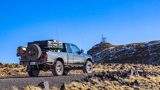
The higher summit - to the south - was the snowier of the two, the road pretty well iced over with the white stuff. It's also the summit with a ton of radio gear, all located a half mile away from the parking area.

Well, we weren't going to get within a few hundred feet only to say we hadn't been to the top, and so we set out on foot - the sun warm but the wind cold - for the last half mile. The views here to the west were spectacular, especially those of Wildhorse Lake in the valley below.

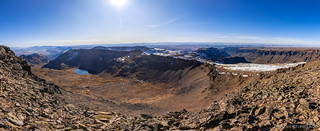
The views to the west weren't quite as good - Steens ridgeline extending out just enough to block the best views of the Alvord Playa below. Still, the jagged ridge itself was nothing to complain about.

Hoping for an even better view from the second summit - officially the East Rim Overlook - we headed back to the parking area and set out north. Only a mile or so away, we could see the East Rim Overlook from our current position and it looked very promising.
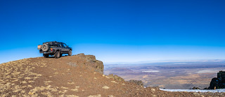
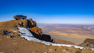
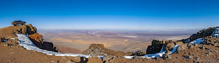
As we arrived, we knew we'd reached the premiere spot on the mountain. Not only did we have a view of the amazing west side of Steens as it dropped over one mile to the Alvord Desert, we also had a spectacular view of the desert itself.

On top of that, because the road on the actual summit is closed half a mile - and several hundred feet - from the top, it was at the East Rim Overlook that we could officially declare ourselves the highest truck in Oregon!
It'd taken us nearly all day - it was now just after 4:00pm - but we'd made it despite our best efforts at self-distraction. And now, we were in a pickle - we had a little less than two hours to get back to Fields Station for fuel before they closed at 6:00pm, and our fantastic cell phone service on the top of the mountain suggested we would arrive at 6:04pm.
It was time to boogie!
@mrs.turbodb had more confidence than I did at this point that we would make it. "You drive a lot faster on these roads than the mapping apps expect you to." she said.
Guilty as charged? I guess I hoped so, as we pressed the speeds upwards of 50mph down the north side of the loop.
Always the thinker, @mrs.turbodb got travel times to several waypoints along our way - the first being to the small town of Frenchglen at the bottom of the mountain. Even by that point, we were already 7 minutes ahead of schedule, but I still figured it was a good idea to call Fields Station and let them know we might be there just a couple minutes after closing.
Turns out, they didn't care - they were closing at 6:00pm sharp, and if we missed closing time, we were welcome to come back the following morning. So the race was on, again!
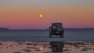
Ultimately, we made it with several minutes to spare and @mrs.turbodb even managed a nap along the way. Our fuel tank full, we headed back to the playa - because any time you can camp on the playa, you should. We arrived just as the nearly-full moon was coming up over Big Sand Gap - a spectacular sight.
Tonight, there was another reason we want to be here as well - reinforcements were on the way. Sometime around 9:30pm we expected to see Ben @m3bassman, Will @willhaman21, and Nate @nateshrum show up on the playa so we could all adventure together the next day.
We eventually picked up Ben on the ham radio - right on time it turned out - and after a bit of blind-leading-the-blind-in-the-dark, we finally got all three of the new trucks out onto the playa and into camp. Smiles, introductory handshakes, and hugs were shared, and even though we were all freezing cold, we stayed up until 11:00pm chatting about this and that, the new guys running around to take photos of their #instafabulous trucks all lit up on the playa as Ben, @mrs.turbodb, and I caught up on each others recent adventures.
Finally though, our feet frozen, it was time to hit the sack. We had big plans for the next day - we were going to tackle Big Sand Gap, the same spot we'd gotten stuck six months earlier - and I for one needed my beauty rest.
Little did I know that Big Sand Gap would not be the coolest thing we saw the next day.


")

")


")

")
")


")
")
")

")


