
We literally woke up in the shadow of Mt. Antero, to temperatures in the mid-20°F's. Despite the cold, I'd slept well - as did the rest of the crew - except for a bit of rustling during the night - little critters having discovered the open bag of chips that we'd left next to the camp fire by accident.

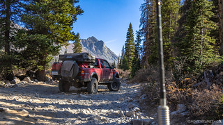
Out of the tent around the same time as Mike @Digiratus, I wandered off - moving to stay warm - while he prepped a hot cup of coffee to achieve the same result. Wandering up the road from camp toward Baldwin Lakes, a granite tailings pile gleamed bright against the weathered rock of the surrounding mountain. I decided to explore.
It doesn't seem like much in a photo, but if you look closely, you can see where rocks have been stacked to create walls - this the entrance to what was once a reasonably large mine shaft.

My position part way up the mountain also afforded me some earlier sun, and I took full advantage to warm up a bit - while the rest of camp was still in the shadow - before continuing up the road that Mike had attempted the previous evening. The road was - as he'd mentioned - rough, and I soon discovered the tracks indicating his multi-point turn. I pushed on, wondering what I would see over the top of the ridge - the answer, unfortunately, was "more trees."
Heading back down, the views - even just peaking out through the trees - made for a nice stroll, one that I thoroughly enjoyed now that my creaky old joints were a bit warmer.

In camp, Dan @drr was up - breakfast made; Monte @Blackdawg and Devin @MissBlackdawg were rustling around in their tent, now willing to venture out that the sun was warming the surroundings.
Breakfast for me was a cold bowl of cereal, so cold that when I rinsed it with water to clean it, the water turned to slush immediately - a pure joy to wipe around with my bare hands, let me tell you! This was a situation I was used to by now - no big deal since I knew that it'd soon be a balmy 70°F under clear blue skies.
By 10:30am we were back on the trail, making our way down the hill, onto pavement, and toward Buena Vista - our destination for the morning. We had several things to take care of in town - each of us needing fuel for our trucks, propane, a few supplies, and a dose of LTE connectivity.


When we'd rolled through Buena Vista for the first time - a little more than a year before - the frosty stand we'd hoped to eat at was closed. Disappointed, we ended up eating across the street at what turned out to be a delicious pub and pizzeria - but hoped that one day we'd be able to return for some burgers, fries, and ice cream. Today was that day!

Turns out, we should have eaten at the Eddyline Brewery again - the burgers and fries only OK, the shakes meh (large at 2 lbs, but with mix-ins that were stale), and the onion rings terrible (reportedly sticking with their owners for a couple days)! Oh well, it was an experience we were after, and not everything can always be splendid - just eating lunch in the park with a bunch of friends was enough that none of us had any regret. 
From Buena Vista, we set off again - out of town the way we'd come in - towards the first of two passes we planned to summit on the afternoon.


Everywhere we went for the first week and a half was under fire restriction.
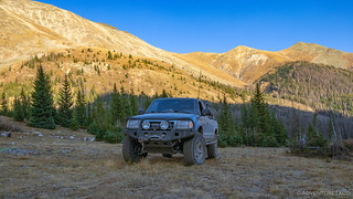
Once again on dirt, the first pass on our list was Hancock Pass. This was one we'd run on the final day and in the opposite direction on our 2019 Colorado trip, and we knew that running it the opposite direction would be a more challenging task. Undeterred, we pressed on, passing the building we'd seen sliding down the hill the year before, still a bit worse for wear.


One really nice thing about running trails in a different direction is that the views you get can make it an entirely different experience. The things that may have been in mirrors - or missed entirely - are suddenly front and center. That was definitely the case here, the mountains above Hancock Lake rising up majestically out of the earth.

A little further on, as we turned off toward the pass, Mike and the Redhead framed it perfectly again.
And with that, we were headed up - lots of up - through loose rocks that grew as we climbed. The going was slow, as we knew it would be, but it wasn't nearly as difficult as any of us thought it might be.


A few locations might have even looked more difficult than they were - two foot ledges, no trouble for our trucks, but a great place to capture an unusual angle, as Monte did when Mike crawled up this section.

Here you see the Redhead in its natural habitat, Monte capturing the move with his patented pivot to gain the ideal angle.
As we reached the pass at 12,140 feet, the views behind were as expansive, if perhaps a bit ho-hum as Colorado passes go.


Now, while I wouldn't necessarily recommend Hancock Pass as a must-do-bucket-list item from a views perspective, there are a couple good reasons to keep this trail somewhere on your list. Obviously, it's a great way to get to Mt. Antero - where we'd spent the previous afternoon - and that is definitely a must do. Additionally - if you ascend from the south, as we'd done the previous year, you can investigate an old railway grade and tunnel with a lot of history behind them. And lastly - no matter which way you access Hancock Pass, it can be used to access Tomichi Pass. And Tomichi Pass was dramatic, but now I'm getting a little ahead of myself.
We started down the south side of Hancock, the shelf-road-through-a-scree-field to Tomichi visible in the distance.

Looks exciting!
Soon, we were at the turn - the road to Tomichi Pass closed at this location when we'd been by the previous year.

As with many of the roads we'd travel this year, the Tomichi Pass road was clearly used for mining at one point in time. Still in the valley and lower than the shelf road, a large tailings pile was visible from quite a distance, and as I was bringing up the rear, I hoped Monte would stop to take a look.

Naturally he did, and by the time I pulled up, he and Dan were already out of their trucks and headed up to investigate a large mine shaft - the remote location enough to keep it from being locked up by the the mine safety folks who would otherwise place bars and grates over any dangerous hole.

I poked around a bit outside, an old boiler - no longer on its stand - catching my attention first. Then of course, the mining claim - for this, the Brittle Silver Mine, was an interesting find. Reasonably new, I wonder if the owner has plans to continue mining the area - or at least to do some prospecting... my guess is that the old timers probably left plenty of the yellow shiny stuff to keep a small, more modern operation, running for a little while in today's day and age.


I couldn't resist a short foray into the shaft itself. Sure, there's some danger in this, but the views from inside are always so dramatic, and while they're hard to capture, the colors in some of these shafts are amazing.

Hancock Pass from the Brittle Silver Mine. (A gold mine, mind you!)
With our exploration of the area around the mine complete, it was time to leave the warm light of the valley for the cool granite grays of the scree shelf road leading to the summit. Unsure what we'd find as far as trail conditions were concerned, Dan led the way as we made our way through this section of trail.


There was only one "where-does-the-trail-go" moment as we climbed, a blind rise falling off to the right - difficult to see as the truck is pointed skyward and you're sitting on the left hand side. We all made it through unscathed - of course - and before long we were at the top. We'd reached Tomichi Pass!

What lay ahead, to our south.

Behind us, the road winding up to Hancock Pass.
Having gotten a late start to our travels, after lunch in Buena Vista, it was shortly after 5:00pm when we crested Tomichi Pass. That meant we were at a high - and therefore cold - elevation, with only a couple hours to find a more suitable camp. We pushed our trucks down the hill, hoping to drop elevation quickly in order to find camp.
Even Ollie was ready to be done for the day.

Can we be done for the day? I would like to play with my squeaky toy, and it's nearly time for dinner.
We found camp about halfway down the trail - at a large opening between towering ridgelines. It wasn't going to be warmer - not now or early in the morning - since those same ridgelines would keep us in the shade, but sometimes a little chill is worth it when the views can't be beat.
We'd found camp in less than an hour, and unbeknownst to us, it was likely the lowest elevation site before civilization. And that meant we had plenty of time to enjoy ourselves before the tasks of the night. Camp setup was quickly taken care of, as was bundling up for the cool breeze making its way down the canyon.

We were at 12,000' - what would be our highest camp site of the trip, and as we clustered around the camp fire, several tasty topics were discussed. First and foremost, tomorrow would be a big breakfast day. Group breakfasts have become something of a tradition in this crowd, and always consist of the same three components - bacon, eggs, and potatoes. Well, plus a side of salsa for anyone who so desires. Second, Mike announced that he wanted to make us all dinner - and not just any dinner, but a dinner of tacos that he'd been working to perfect over the previous months. All he needed was to get to camp a bit early so he had time to prep before it got dark.
So yeah, yum.
The propane camp fire kept us warm until we all hit the sack just before 11:00pm - our dreams tasty as we nodded off to sleep. We had no idea that the next day would bring not only good eats, but also some of the coolest old mines we'd ever encountered!


