
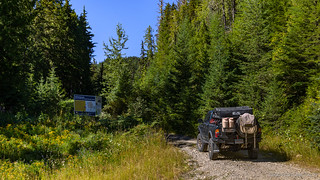
It was nearly 4:00pm when we turned onto the Rady Creek Forest Service Road and popped out of our trucks to air down our tires. I'd thoroughly enjoyed this trail when I'd rushed to Canada nearly a year earlier - worried that it was about to be deactivated (closed) forever - and from our conversations prior to departure, I knew that Mike @Digiratus was really looking forward to seeing this place as well.
I didn't choose the best spot to air down - I was both blocking the trail and in the sun! 
As with our run up Mt. Buchanan, our journey began with a series of switchbacks that worked their way up the steep slopes, trees and shrubs crowding road. It was narrow - even for a couple of 1st gen Tacoma's - but nothing that was going to keep us out; these pinstripes wouldn't be the first that our trucks have seen!

By the time we were done, both Mike and I had to readjust our CB antennas, which had taken a beating.

As our elevation increased, peek-a-boo views began to appear to the north...

...and to the west.
Two thousand feet of elevation gain later, we came upon the infamous deactivation sign. Still posted with the original date, it'll be interesting to see what ultimately ends up happening with this area, and whether the petition that was signed by nearly 10,000 people has any effect on the outcome.

This is where the road starts to get steep and a little loose as the switchbacks abandon their leisurely back and forth across the mountain, anxious - like us - to get to the top!

For anyone interested, I suppose it can't hurt to give Mike Ferguson a call, to help keep Rady open.
Pushing the trucks into 4Lo, we climbed another 2,200 feet before reaching the first dramatic overlook of the alpine wonderland above the tree line. This wasn't the place where we'd end up for the night - the views there would be even better - but this was the first spot where I'd been wowed, and I wanted Mike to experience the same on his first visit.

This wouldn't be a bad spot to camp... if there weren't several better spots just a little further up the trail!

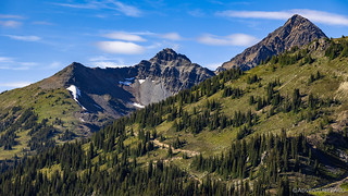
The views up here seem to go on forever.

Roads wind through the bowl and climb to the ridge, all waiting to be explored.
In the near distance, a hint of what's to come. #excited
As with many trails that usher adventurers high into the mountains, this one splits off in several directions. Originally carrying prospectors to various dig sites, the roads slowly transition to two-track and eventually single-track as they wind their way through meadows towards destinations long forgotten. If cabins or other significant structures once existed - where stories of gold and soon-to-be-riches were told - they are gone without a trace. Today, campfire rings serve a similar purpose, though the stories are of adventure and exploration.
And so, for an hour, we hopped from ring to ring, admiring the views that those who'd come before us deemed worthy of extended enjoyment.

Meandering through a meadow.

Navigating a narrow shelf road.

Lounging at a lake.

Surging up the switchbacks.
Through all of these places, I wondered if Mike would find one particularly to his liking. Part of me hoped he would - as it would mean camping somewhere different than I'd camped before. Part of me hoped that he wouldn't - as it would mean getting to camp in one of the most beautiful places I've experienced, again.

We have arrived.
After a short discussion - where I'm sure Mike picked up on my desire to pull my front tires to the edge of the ridge before unfolding my tent - it was agreed: this would be our spot for the night; the same spot I'd chosen the last time I'd been through.

With 14" of careful rock stacking, the Tacoma was still not at all level. I didn't care, I was camping on the edge.

As the sun crept toward the horizon, a golden glow enveloped the landscape.
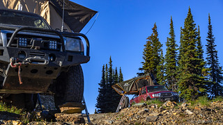
With his tent deployed on a significantly flatter area just a bit further from the edge, and with a burn ban in effect for the entire province, Mike broke out the propane fire pit as I made and consumed my usual dinner - tacorittoes - before donning some protection from the blood-sucking-vampires that were swarming around my person.

This would become a familiar scene over the remainder of the trip.

As the sun set, the moon climbed into the sky.

I never tire of these views.
As the light waned, found myself curious about the Diode Dynamics SS5 Pro LEDs that I'd installed earlier in the year. In fact, it was deja-vu all over again - you see, the last time I'd visited I'd been excited about the SS3 Pro fog lights I'd just put on the Tacoma.

Even with a significant amount of light still in the sky, things were looking promising for the SS5s.

I knew the SS5s would illuminate the hillside better than my Hella 700s had, but I wasn't prepared for how laser-focused the beam would be!
We couldn't stay up around the campfire forever - though this was most definitely our latest night to bed - so after a little more than four hours of chatting and enjoying each other's company, we bid the other good night just after 11:00pm.

No shortage of stars way up at 7429.1 feet in the middle of the Kootenays.
The Following Morning...
I knew my attempt at leveling the Tacoma the previous evening was not the greatest, but I didn't realize just how bad it was until I tossed and turned all night. Waking up in a corner of my tent more than once due to the incline, I was both happy - and groggy - when daylight broke, and it was time to climb down the ladder.

Truck looks pretty level. Isn't.

With the sun now shining out of the east, the mountains that had been in silhouette the previous evening, gleamed.
It was still early, so I wandered around the hillsides for an hour or so until I heard Mike prepping his first cup of morning coffee. Like me, the natives were scurrying about, checking out anything that'd changed while they'd slept, and enjoying the warmth of the morning sun. I must say, they are lucky to call this wonderland home.

This marmot poked his head up just a few minutes after I started my walk. He'd follow me - always keeping a safe distance - for much of the morning.
Maybe I should take a cue from Mike's decision to camp on flatter ground - even if it is a little further from the edge... Nah!

I thought this lichen was really interesting because it all seemed to be outlined in black. Perhaps the edges die back each winter?
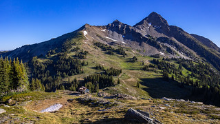
I'll never get tired of this view.
Eventually, around 8:00am - as I heard Mike up and about - I made my way back to camp, my marmot buddy still in tow. I don't know if he has gotten treats from other campers, if he was just curious, or if I already smelled like marmot after a couple nights on the trail, but whatever the reason, I shooed him away. Getting too friendly with humans never seems to end well for the wildlife.

Mr. Marmot was still shedding his winter coat.
It didn't take long to stow away camp, and soon we set out to explore the last half mile of trail that we'd opted to leave unexplored when we showed up the previous afternoon. It was a good thing too, since I think we passed a few camp sites that Mike may have lobbied for had he seen them earlier!

Away we go, Mike leading the way.

It'd mean staying for a full day, but eventually I hope to hike to the top.

Looking across Trout Lake to (I think) Mt. Hadow.

Picking our way through wildflowers.
Eventually, we reached the end - for us - of the road. Here, the two-track changed to single-track, and only dirt bikes and hikers could continue on. Perhaps in the future - when I return to hike some of the surrounding peaks, I can see where that trail leads as well. For now, though, it was time to turn around and get on our way down; we had a full day ahead of us, even if it was extremely pleasant where we were.

Headed down off the mountain, a Radiant Red Tacoma sure does stand out.

Clear blue skies contrasted wonderfully with the snow-capped peaks.
We stopped several times on our way down to soak in views that may not be so easily accessible in the future.

I'd missed this camp site-with-a-view on our way up. An option for next time!
(Note: My front tire is in the fire ring, for those who are sure to comment that we are not staying the trail.)

...Maybe not though - it was a little close to the road in the event anyone else showed up.

Sometimes it's best to put the camera down and just enjoy the view.
Eventually - we weren't setting any land speed records in our descent - we neared the tree line. Below us, the last grassy valleys gave way to woods. Snow melt filling the lowest of the lakes before rushing down the mountain in a series of creeks that would terminate at Trout Lake.

Alpine awesomeness.

Final views as we head into the trees.
The tree-tunnel portion of the trail was as boring as always, though it requires a bit of attention - given the crowding of willows into the road - to keep the truck centered as one bombs down the trail. Luckily we didn't encounter any oncoming traffic, though as I reached the bottom - a few minutes before Mike - there was a white 5th gen 4Runner airing down for the ascent.
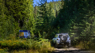
@aldventures heading up the trail.
Waving as I got out of the Tacoma, he came over to ask about conditions. "They were great," I related, "and you'll be the only one up there after my buddy gets down." As I said it, I noticed his eyes go to my license plate cover and a smile light up his face. Turns out that my trip report from last year - which he'd been reading as early as that morning - was one of the things that brought him to this trail! What a small world we live in!
A few minutes later, Mike pulled up behind me and we bid farewell and good luck as we set about filling our tires with air. The rest of the day would be on pavement or well-graded gravel as we made our way north to Revelstoke and Rogers Pass before heading south towards Radium Hot Springs and the area where we'd spend the bulk of our time.

Even though Mike's Dual ARB compressor sounds like it is on its last legs, it still fills tires a lot faster than my single CKMA12.
It'd been a fantastic start, but looking back now, the best was - by far - yet to come!


I'm not sure why that green lichen has a black outline, but the lichen is called a Map Lichen (Rhizocarpon), it is in the catagory of lichens called crustose lichens (those mostly on rocks). UJ
Looks like a great trip.
Thanks! Was a great one for sure! Make sure you check out the highlight - Hallowed Ground - M&M #4. Simply stunning. ?