 - Cedar Mesa #3")
We got another good night of sleep on the edge of Bullet Canyon, and were up bright an early - or more correctly, dark and early - to start prepping for our long day. We were going to leave the truck and tent set up while we hiked - no need to pack all that away just to unpack again on our return - so we ate breakfast, made lunches, and filled every container we'd brought along with water. We were, after all, going to be hiking more than 17 miles - much of it in 90°F heat.

About 3.5 gallons.
I make the water situation sound sketchy, but we'd done some calculations based on the previous two days, and it seemed like we should have enough - assuming something didn't go terribly wrong and we were forced to spend the night or backtrack the majority of the distance. So yeah, just a little sketchtastic.
Everything ready to go, we departed camp just as the sun peaked over the horizon and spilled onto the mesa. We were getting an early start - and that was good. Not only would it allow us to cover some ground before things warmed up too much, but it also allowed us to take a more leisurely pace, exploring interesting discoveries along the route.

Couldn't ask for a nicer morning.
Before long, we found ourselves scrambling down the canyon walls - imposing from a distance, but there almost always seems to be a workable route once you get close enough.
I've mentioned the distance, but before going too much further, I should cover our plan for the day. I'd originally wanted to hike Bullet Canyon, primarily to see two ruins: Perfect Kiva and Jailhouse. As I'd researched the route prior to our departure, I'd come across several folks suggesting that, rather just hiking out-and-back - a 12 mile roundtrip, a better option is to hike all the way down Bullet Canyon, and then hike back up Sheiks Canyon - making the trip into a 17 mile loop. The main benefit of this, is that for just five extra miles, there is a lot more to see - both because we wouldn't be backtracking and because Sheiks Canyon is full of goodies.
Note: Visiting both Bullet and Sheiks Canyons require a pass - even for day use. For more information, check out BLM Utah Cedar Mesa Permits and Passes Information.
So, that was the plan. Actually, at the time we thought it would be 14 miles, but we neglected to factor in the mileage necessary to leave the main trail to visit all of the ruins. And that's how we ended up with a 17 mile track by the end of the day!

Heading down into Bullet Canyon.
Miniature arch.
Opening up into the new day.
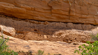
Now walking down the wash, the going was easy and @mrs.turbodb was the one who spotted a tower ruin up on the rim of the canyon. With no mud chinking, I'm unsure if this had been rebuilt, but it was cool to see, regardless.

Perhaps one of a series of communication towers along the rim of the canyon?
With no idea what to expect along the way, we were curious from the start, and didn't hesitate to stop for a few minutes here and there as we ran into things that caught our interest.
Flaking layers.

Parts of the trail were covered in fluffy "snow." Only this snow wasn't cold, unfortunately.
A mile or so into the hike, we reached the second of several major drops in Bullet Canyon. In all, we'd drop some 1200 feet over its 7 mile length, but this was by far the most dramatic - the trail following a fantastic dry fall through a sandstone maze, the canyon walls rising up all around.

We loved this half mile of trail, and were glad to be doing it before the sandstone heated up in the afternoon sun.

Exiting the dry fall, we were in a whole new world.

Nature's cairn, calling our names.

I've seen this cartoon before; glad I'm not a coyote.
We continued a slow descent now - the next couple of miles bringing fabulous discoveries around every turn. It was so pleasant hiking in the canyon at this time of day, I'd really recommend it to anyone - even those who aren't interested in the ruins further along. Just remember: you have to climb out, too!

The wispy clouds added a nice soft touch to this bold sandstone outcropping.
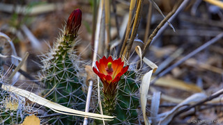
The most vibrant Claret Cup I've ever seen.

I see you down there. You're not going to eat me today...
As we continued to crisscross the bottom of the canyon - the trail mostly staying out of what must sometimes be a wet wash - the sun continued to climb in the sky, and a couple hours into our hike, we were out of the shade, and happy that the sun was at our backs.

Sheer wall.

Our first destination - Perfect Kiva - lay in the large alcove.
It was at this point that I realized that the GPS waypoints I had for various sights along the way were simply suggestive. That was fine, though as I mentioned, by the time we were done, it added a few miles to our day. Not wanting to miss one of the primary reasons we'd done the hike in the first place, we scrambled our way up to the alcove and were rewarded with our first success.

Perfect Kiva.

The entrance.

@mrs.turbodb: "Are you really going down there?"
me: "Yes, definitely."
As I explored the site, @mrs.turbodb read through the ammo box of material left by the BLM for anyone lucky enough to find themselves in this special place. The history of Perfect Kiva was interesting to say the least, and revealed that the site may not be as "perfect" as the name suggests.
Welcome to Perfect Kiva
Rock art found here indicates the Basketmaker people were the first to occupy the site, between 1500 BC - 750 AD. The structures you see, however, were constructed during the Pueblo Il and Ill periods from 900 - 1300 AD.
On the far right of the alcove, you can see more pictographs, which include a white symbol that is thought to represent an atlatl. Since atlatls were used by the Basketmaker cultures, archaeologists determined that the Basketmaker used this site before the Pueblo culture, which by then had developed the bow and arrow.
The free-standing rooms built into the massive boulders around you were probably used for storage, indicated in part by the vast amounts of corn cobs on the floor. Another clue suggesting use-as-storage is the lack of black staining on the ceilings or back walls, typicality a strong indication that the space was used as habitation rather than storage.
For the construction of the kiva, a circular hole was first dug, then a bench was built along the inside with columns interspersed along the bench. These rock structures were plastered with adobe, and large beams laid horizontally across the columns with one end on top of another (cribbing). Smaller beams would then be laid across these side by side, while still smaller beams would be laid across these in the opposite direction, with branches & juniper bark laid on top of the beams to form the roof. Finally, a layer of adobe would be laid over it to cap the structure.
The BLM, in concert with multiple organizations, conducted stabilization of the site in 1976, the late 1980s, and again in the mid-1990s. During the 1976 stabilization, the roof of the main habitation room behind the kiva, which was collapsing, was pushed back into place where it stands today.
The T-shaped doorway is a common architectural feature often found as an opening into a habitation room. To the left of the main habitation room, you can see a large rock, or metate, that was used for grinding corn. You can also see faint yellow geometric pictographs.
There is a small niche located in the center of the back wall of the kiva, and just to the right of it, you can see the signature of C.H. Graham, Jan 11. He was one of the first people to excavate the site. The waxy looking substance on the walls of the kiva is petrified pack-rat urine.
Charles McLoyd and Charles Cary Graham from Durango, Colorado, organized the first archaeological expedition into Grand Gulch in January of 1891. The Wetherill-Grand Gulch Research Project (1986 - 1990) used the signatures of explorers to trace and confirm the routes of the early expeditions. The signatures proved to be a valuable insight into what the project termed "reverse archaeology."
There is another figure on the wall behind the habitation room, and to the left is another Graham signature. To the right of the habitation room, you can see handprints and the signature of another early explorer, H. French, with the date 1/8/94 above it.
Please respect and do not touch these valuable signatures.
You are in a very fragile archaeological site. Please follow the Visit with Respect tips to help you visit this site.
Well, that description - and the fact that we could see a few edges of the plywood used to reconstruct/reinforce Perfect Kiva - took a bit of the magic out of it for me, but was great to know nonetheless. We continued to investigate the site a while longer - to stay out of the sun as much as anything - before venturing back to the main trail down the canyon.
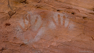
White hand negatives.
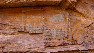
This was an intriguing polychromatic panel that was originally inside a dwelling.
While it taken us a couple hours and five miles of trail to get to Perfect Kiva, our next stop - at Jailhouse Ruin - was less than a quarter mile away, at least, as the crow flies. Double that for route finding up the side of the canyon wall, and it still didn't take us long to spot the iconic white circles (faces?) above the ruins.

Back on the trail.

The inhabitants were either really good climbers, or had a ladder.
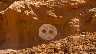
A dramatic sight. A warning to visitors?
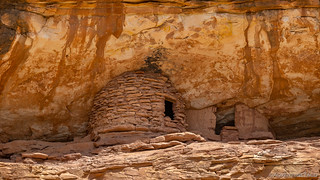
As striking as the rock art above this site may be, the name comes from the wood lattice window in one of the structures. It's not clear whether this latticework was left purposefully exposed or if part of the mud wall fell away, but whatever the cause, it surely adds interest to this small set of ruins.

Not a very secure jail.

A wooden substructure was clearly used for many of the buildings

Handprints and patterns over soot.

A nice tafoni.

We found enough of this pattern to nearly construct an entire bowl.
With another mile and a half to the intersection of Bullet and Sheiks Canyon - the apex of our loop - we were back underway just as another couple showed up at Jailhouse Ruin. Quick good mornings were shared, and we left them to admire as we'd done, our trail continuing west down the canyon.

The Bullet Canyon views never let up.

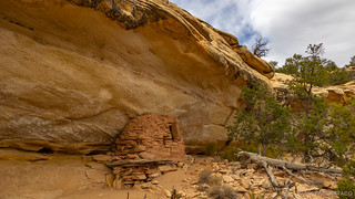
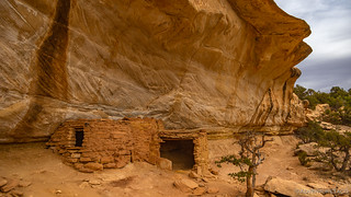
I really liked the black water stain that snaked down past a granary ruin.

As we got closer, this tree in front of the granary caught my eye.
I'm always intrigued by the varied construction techniques. I wonder what leads to a rock exterior vs. mud?

The mouth of Bullet Canyon as it merges with Grand Gulch flowing to the left. Sheiks Canyon merges in here from the right.
We'd covered seven miles of trail, perhaps a couple more with our side trips, and we both felt great. Our water situation was not a problem at all - despite two small leaks that we'd discovered in the containers we'd brought along - and we decided that a shady spot at the intersection of the canyons was a great place to rest feet and shoulders for a few minutes while we ate lunch.

Filtered shade, a nice respite from noon-time heat. (87°F)
Cognizant that we still had a way to go - and that we weren't entirely sure we be able to climb out of Sheiks Canyon (more on that in a moment) - we easily polished off our sandwiches and some chips, but we shared an apple and left our stash of four granola bars untouched. You know, just in case. We also redistributed water to reduce leaks, and then reshouldered our packs as we set off - the trail now leading up Sheiks Canyon, the sun at our back once again as it passed overhead!
Unlike Bullet Canyon, where the canyon itself was fantastic, but there were only a few historical sites along the way, Sheiks Canyon was packed with ruins and rock art, making it perfect to keep us moving - from one site to the next - on the second half of our journey. And it wasn't long before we came to Wall Ruin.
Rather unassuming, and reasonably hard to access.
Getting to the ruin was going to require quite a bit of scrambling and the scaling of a reasonably sheer cliff, so @mrs.turbodb sat this one out while I looked for the easiest route up. I was glad I did, because the ruin itself had some interesting little treasures.

Hidden room.

The geometric "stairs" on the right were especially intriguing.

Patterned prints.
A horse-collar entrance.
It was as we were leaving the Wall Ruin that we passed another group coming the opposite direction. As with the rest of the hike, there was a network of trails along the bottom of the wash, and in this particular location, we were separated by a 15' mini-canyon between the two trails. We shared greetings of course, and then asked where each other were headed. When we mentioned our plan to head up and out Sheiks Canyon - the route they'd taken in - the looks on their faces were of incredulity.
"You're going up?" "It's pretty steep." And, "Oh."
Well then, those reactions were certainly reassuring.
Not to be deterred, I asked for a bit more explaination, and soon realized that the description of climbing through boulders, and scrambling up loose dirt was exactly what we'd encountered on our way down through Bullet Canyon. A grin spread across my face and I glanced at @mrs.turbodb as I chuckled and said, "Wish us luck!" I'm not sure how she was feeling at that point, but I knew we'd be in camp for dinner.

We found some deep shade at cave ruin not too much further along, and stopped to cool down.
There are two significant climbs on the route out of Sheiks Canyon, and the first comes just a few hundred feet after the site I was most looking forward to seeing - solely due to its name - along the route: the Green Mask Site. As with many, the site was built into an alcove along the side of the wash, and I figured there'd be a fabulous green mask pictograph somewhere on the walls.
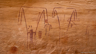
It turns out, there was so much more. This was one of the most interesting pictograph sites I've visited, with several civilizations inhabiting this same shelter.

Colorful work of the artisans of the hunters and gatherers of the Archaic Period. (6500-1500 BC)

Black and cream colored plant representations. (Archaic)

Unfinished works of the Basketmakers. (BC 500-750 AD)

Striking female imagery.
A breech birth. Apparently, an adult woman mummy, who had died giving a birth to a breeched baby, was found under this panel.
Welcome to Sheiks Canyon and the Green Mask Site
The rock art is the most notable feature of the Green Mask site, including the green mask for which the site is named. Based on the rock art styles in this alcove, this site has offered shelter to people for thousands of years. There is evidence of occupation dating from the Archaic period (6500 - 1 500 BC) through the late habitation of Puebloan people around 1260 AD.
On the eastern end of the alcove, high on the wall and the ceiling is the colorful work of the artisans of the hunters and gatherers of the Archaic Period (6500-1500 BC). In pigments of black, red, white, and cream are abstract paintings of plant and insect-like forms, as well as other typical images of the period.
The large rock boulders around you on the alcove floor and the reddish rock scar on the wall directly below the Archaic paintings indicate there may have been a rock shelf used to access the upper wall. Basketmaker Period (BC 500-750 AD) style rock image over the rock scar reveals the shelf may have fallen before the occupation of the site.
Painted images midway and lower on the back wall of the alcove are also Basketmaker style. The Basketmaker style includes square-shouldered humanlike figures often with headdresses, positive handprints, bighorn sheep, lines, dots, and zigzags.
High on the far east end of the alcove is the elaborately painted mask-like figure in green, yellow, white, and red pigments. In a Basketmaker Period burial site in northeast Arizona, a full-face scalp or mask was found that had green and yellow stripes and red bobbed hair, almost identical to the mask painted on this wall.
The rock art of the Pueblo period was often less abstract than that of previous periods. These styles included shield-like figures, concentric circles, spirals, pawprints, handprints, bighorn sheep, birds, and mud balls.
It is thought that this site may have had as many as 13 structures. There are several small below-ground storage units called cysts, and two above-ground structures on the lower level of the site that have curved walls could have been kivas.
In the 1890s, early explorers Charles McLoyd, C. C. Graham, C. H. Green, and the Wetherill brothers visited Grand Gulch. They collected pottery, baskets, clothing, tools, arid human burials for private collections and museums. Many of the artifacts were exhibited in major cities and sparked public interest in the archaeology of the southwest.
On the upper level Of the southwest end of the Green Mask site are signature inscriptions of "C. McLoyd and C. C. Graham." The signatures are an essential link to the story of the site. Archeologists and historians have traced some of the extracted artifacts back to the specific site from which they were taken by using these inscriptions along with expedition journals and statements of expedition participants.
Of course, through all of this, our eyes were peeled for the Green Mask. Surely it would be a large glyph in a prominent section of wall - the site was, after all, named after this work. Ultimately, it took us two sweeps of the entirety of the alcove to find the mask. High up on the ceiling, it was much smaller than we'd envisioned, perhaps only 16 inches tall and and 12 inches wide.

In a Basketmaker Period burial site in northeast Arizona, a full-face scalp or mask was found that had green and yellow stripes and red bobbed hair, almost identical to this mask painted on the wall.
And with that, we began our ascent out of Sheiks Canyon. We'd gain nearly 600 feet - half of our elevation - in the next quarter mile or so, making our way up a rocky dry fall, and some loose sandy sections of trail. As we did, the views opened up behind us.

This is why I wasn't worried. I constantly forget that people's definition of "hard" has taken on a new meaning in the last decade or two.

It's no Bullet Canyon, but I wouldn't mind living in a cliff dwelling here, either.
With food and water no longer a concern, we each drank our fill, and shared the second apple we'd brought along in the deep shade of a rocky cave at the top of the major climb. I must say, Cosmic Crisp apples really are the best.
We stopped at three more ruins on our way out of the canyon, though none of them were as interesting as what we'd already experienced. We were starting to feel the miles on our feet and quads at this point - though my knees were surely happy that we were headed up, rather than down - and as if to give us a little bit of a break, a cover of high clouds helped to temper the sun just a bit.
A granary at the Yellow House.
Yellow House, bright even in under cover.
A mile later, we reached the trailhead for Sheiks Canyon. It was a bittersweet victory - not because we wished we were back in the canyon, but because we now had four miles of dusty dirt road to cover in order to complete the loop back to the Tacoma, which we'd left at the head of Bullet Canyon!

Two cairns marked the trailhead. A false victory.
We arrived back in camp just before 7:00pm, both in full agreement that the absolute worst part of the entire hike had been the reasonably flat - and 100% completely boring - road to camp. Our feet hurt, and we collapsed into our camp chairs overlooking the canyon. We'd done it, and with no drama.
After resting for a bit, we dragged our tired butts back to the truck and assembled dinner. We washed up a bit, and then a few minutes after sunset, we climbed into bed.
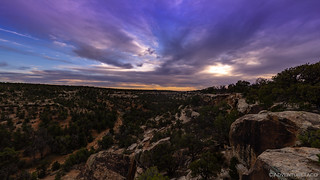
A celebration in the sky - of our success.
Tomorrow, we'd start the long journey home - a few sites to visit along the way. For now, we'd earned every bit of sleep we got.


WOW WOW WOW!!!!!!! Thank you for sharing your amazing life! This is great. Now to get caught up on all that you’ve already written! I just found you from a post on Facebook.
Have fun reading, and by all means if you have questions - ask! ?
We’re hiking Sheiks Canyon in a few weeks. I’m worried we’ll have trouble at two spots where I’m told you have to orient around the canyon, first north, then south. Any suggestions?
Hi Cindy, I’m not sure I totally follow your question about orienting around the canyon, can you ask it again with a bit more detail or specifics as to what you mean?
Turbodb,
Did you get my reply, and do you have any suggestions to help me route find the area where you have to go around the boulder field? Thanks.
Hi Cindy, I never got any reply to my question above, so if you could ask it again here, I would appreciate it. I’m still not exactly sure what you’re talking about with orienteering and a boulder field.
Hi, thank you for this great article!
Is the road to bullet canyon trailhead ok to do in any kind of car?
Considering doing this loop next time I travel to the US (I'm from France and love the West)
I would say that you definitely don't need 4WD or high clearance, but you don't want to be driving a low-to-the-ground sports car, either. You'll need to be a bit careful with the line you choose in order to avoid rocks and potholes.
Also, be aware that permits are required to park and hike in this area, so you'll want to be sure you pick those up before you come. Check out BLM Utah Cedar Mesa Permits and Passes Information for details.