
One of the things that surprised us when we climbed into the tent just after 6:30pm, was that there wasn't much wind up on the top of the platform. Not that we were complaining.
But it wouldn't last. By midnight, it was windy and we'd both put in our ear plugs to quiet the flapping of the tent fabric, as larger gusts rocked us in and out of sleep. Still, by sunrise - some 12 hours later - we'd both gotten enough sleep to feel reasonably well rested, and certainly more energized than we'd been after our hikes the day before!

Rays of light betray the position of the rising ball of fire.

Layers of light.
From our vantage point at the very end of Owlshead Mountains Road, the time just before the sun broke the horizon was sensational. The light transitioned from blue to purple and back again, the cloudless sky offering a smooth transition across its entire dome. I took full advantage.

No one else for miles.

From California to Nevada.
Eventually, it was time to get going. I put away the tent - not an easy operation in the wind - while @mrs.turbodb fixed breakfast and lunch. Soon enough, we were enjoying Peruvian blueberries with our Cheerios as the sun began to warm our bodies.

The last of our tasty tuna, shoveled into sandwiches for easy access later.
It was at this point - before we'd even driven to our next trailhead - that we made our first mistake of the day: we decided to store the sandwiches in the fridge, rather than take them with us on our hike. But, more on that later...
At this point, we had no idea that it was a mistake, and we drove into the sun, retracing the entirety of the road system that we'd navigated over the two previous days.

Driving into the sun is never ideal, but it does make for some cool silhouettes.

As we passed Lost Lake, a family of easily-spooked burros kept a watchful eye.

A few minutes later we passed Owl Lake.
Near the end of our (wheeled) journey - and as we were reaching Owl Hole Springs Road - we found ourselves with a view into the Naval Air Weapons Station China Lake (NWC) that @mrs.turbodb had missed on our way in - the lack of sleep catching up to her a couple days earlier as we bumped along in the opposite direction. This morning, however, she was wide awake, and we took a few minutes to check out a platoon of vehicles scattered across a dry lake bed in the distance.

Targets.
I took the opportunity to suggest that one of us - ideally, me - could run out there to get a closer look. It looked to be only about eight miles or so, one way. Only 97% sure I was joking, I was told in no uncertain terms that I would not be dashing across miles of possibly unexploded ordinances. I smartly relented with only a bit of a fight. 
Ten minutes later, we pulled over again. This time, we were about halfway down the smoothly graded Owl Hole Springs Road, at the spot I'd determined to be the best place to begin our hike to Military Canyon.

Our route (pink) vs. the original route (green).
Military Canyon was a hike I'd discovered on Steve Hall's web site before he'd taken it down. It intrigued me for a few reasons: first, I'd very much enjoyed his hike to the Smoke Tree Slot Canyons a few years earlier. Second, it was in the Owlshead Mountains - so convenient. Lastly - and for me, most importantly - Steve had named it Military Canyon because there was an old fuel tank dropped from a jet, and an old weather dart located along the route, and I love seeing stuff like that!
Steve, of course, had taken the green route - but at this point, we still had no idea of the mistake we were about to make.
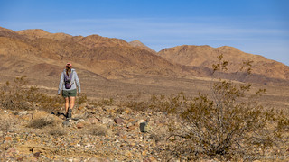
On our way across the broad alluvial fan of the Owlshead mountains.
It's here that I should mention that we'd decided to leave our lunch at the Tacoma. We had no real desire to eat warm tuna sandwiches, and the hike wasn't all that much longer - maybe only a mile or two - than the hike we'd done to Crystal Hills the previous morning. As such, we figured that it might be 1:00 or 2:00pm when we returned - no big deal.
But almost immediately we realized that the drawback of hiking across the alluvial fan - saving ourselves a mile in distance, and the elevation gain walking up the fan from Harry Wade Road - could quite easily be offset by the up-and-down over each rutted wash between us and the mouth of the canyon.
We soldiered on, after a brief discussion about how - even if we'd started at Harry Wade Road - we would have to choose all the right forks in the maze of washes in order to end up at the correct canyon.

Doing our part.

Also found this blowing across the desert. A fellow adventurer, I'm sure Guy Starbuck is happy I collected it.
About two miles into the hike, I just happened to glace east (up the wash we were traversing), and noticed something white at the base of the mountains. Thinking it must be a sign of some sort - but at a loss for what it would be doing in that location - I pulled out the camera and snapped a quick photo.

What the heck is that? Looks like some sort of rocket? Is it an undetonated missile?
If it was an undetonated missile, you can bet your net worth that I was going to see it, so I pointed it out to my hiking companion and after a quick conversation - the detour would add a mile to our already-long hike - we headed that way.

Not a missile. Made of cardboard and covered in foil, our guess is that it is some sort of weather instrument that fell out of the sky and embedded itself in the ground. Still pretty cool.
Update: It turns out that this dart is a towed aerial gunnery target. It would be towed behind another aircraft on a few thousand feet of cable and shot at with radar assisted gunsights. The diamond part on the tail end of the target is a radar reflector!
At this point, we were feeling - or at least, I was feeling - quite justified for taking this route. "We'd never have seen that if we'd come the other way," I offered up to @mrs.turbodb, who was clearly not enjoying the up-and-down of the 20+-foot deep wash walls. 
Plodding on, every mile or so, we'd find an extremely large shell casing, and add it to our collection of desert trash. I quite enjoy cleaning up the desert - it seems like a little thing I can do to give back a bit for all the wonders it has shared.
And then - around noon - we reached the mouth of the canyon, and one of the main things we'd come to see: the fuel tank dropped from a jet, decades before.

My first thought on cresting the hill was that the tank looked like a fish out of water.

Another angle.

Severed - or jettisoned - control lines.

Well there's the problem, it's missing the gas cap.

@mrs.turbodb stands next to the tank for a size reference.

Now I'm just playing with angles.
Having spent more than two hours making it the 3.5 miles to this point, it was time to take stock of our water and food situation. As I've mentioned, our lunches - by design - were back at the trailhead. I hadn't had any water to drink yet - so still had 40, luke warm ounces, in my Camelbak bottles. @mrs.turbdob was a little more than halfway through her 1.5 liters. I'd grabbed a couple of granola bars before we left the truck, and so @mrs.turbodb ate one, while I held off for the time being.
It certainly wasn't the ideal situation, but neither was it dangerous - yet.
A short discussion ensued, and I offered that I could do the canyon loop, while @mrs.turbodb took a bit of a break, but in the end, she decided that having come this far, it would be a shame to miss the canyon itself. With that, we set off up the southern wash.

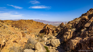
Colorful walls were everywhere as we entered the Owlsheads for the final time this trip.
Where the slog to the canyon had been... a slog, the wash winding a mile into the mountains was nothing short of fun. Changing scenery, dry falls to climb, and bits of shade here and there from the canyon walls made it a much more enjoyable experience.

Up canyon.
Down canyon.

Splashes of color.

Resident scurrier.
By the time we'd wound our way up one canyon, crossed over a ridge, and exited the Owlsheads from a completely different canyon a little further north, it was two-and-a-half hours later, and it was clear that the lunch we'd planned to eat was going to be significantly more like dinner.
And, it was at the mouth of the second canyon that we had a discussion I'd never envisioned having while out on a hike in the middle of the desert: I mentioned the possibility of @mrs.turbodb continuing down the wash - following the original route - to Harry Wade Road, while I headed back across the alluvial fan to the Tacoma, before driving to pick her up.
Neither of us liked this solution - splitting up with relatively little food and water generally being a bad idea - but we both knew it was probably the right call given our location, energy levels, and the amount of water we had left.
With that, I poured some of my water into her Camelbak and handed the GPS to @mrs.turbodb - making sure she knew to follow the route east rather than take some random path - before I headed south toward Owl Hole Springs Road. Knowing that her route would be quicker, I also told her I'd start up the wash along the trail if she wasn't on the road when I got there.
Low on water, we'd split up in the desert.
While the hike out to Military Canyon hadn't been much of a slog for me - the scenery constantly changing and the thrill of the adventure fresh in my blood, the two hours back was most definitely a trudge.

By the time I got back to the Tacoma, I had quite the collection of 50-caliber and larger shells.
Note: Since collecting these for recycling, I've learned that anything manmade that is more than 50 years old, is considered historic and protected by federal law. As such, if you find shells like these on your own adventures, please admire them, but leave them be for others to find them as well - as you would with any historical mining structure, cabin, etc.
In fact, I still have all the ones I picked up - as to be honest, I wasn't sure what to do with them. Usually when I'm out camping and I collect a ton of casings, they immediately get recycled, but I've had trouble with these for some reason - perhaps a good indicator of the 50-year policy. I've offered to turn them over to the NPS, or to redistribute them across the desert on a future trip. I'll update this note as the story unfolds.

Finally seeing the truck in the distance was a sight for sore eyes (and tired legs).

It was here that I drank the last of my water.
Back at the truck, I didn't waste any time racing down the last few miles of Owl Hole Springs Road and the then north up Harry Wade Road to the spot I expected to find my companion. It was 4:20pm - we'd been gone for nearly seven hours - twice as long as we'd expected.

Exiting the Owlsheads solo.
Anticipation, and then relief, are the feelings I had as I neared the trailhead and saw @mrs.turbodb get up from the shade of a large creosote along the side of the road. Though her path was longer, she confirmed that it was much easier and most definitely the right call for her to head this way. She'd arrived about twenty minutes before I had, consuming the last of her water once she reached the road.
Happy to be reunited, we set up shop in a nearby wash and availed ourselves of the food we'd so foolishly left behind. Guzzling and gobbling, I don't think we've eaten faster, nor has tuna ever tasted so good. And then, with 45 minutes of sunlight left, we pointed the truck north and started our 21-hour drive (over three days) home.
A mere 15 minutes later, as we transitioned from Harry Wade Road to Badwater Road, we made our first stop. It was a planned stop - this is where we needed to air up and add fuel to the tank - but even if neither of those things were necessary, there was no way we would have kept driving.
For the first time ever, we'd run into a wagon train.

Wait, what?
Turns out that this group of enthusiasts have been wagon-training-it up the length of Death Valley - along Harry Wade and then West Side Road - for the last 60 years! A two-week journey, they have three layover days, and the rest are spent following in the footsteps of the settlers, literally.

Beautiful black stallions.

Braided manes.
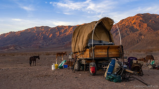
Wagons, with a few upgrades for comfort.
We chatted with the group for twenty minutes or so before bidding them safe travels and returning to our tasks of prepping for pavement. We had three hours of driving to the spot I hoped to camp for the night, and the moon was already setting as we rolled onto the highway.

We couldn't have asked for a better sky as we parted ways with Death Valley.
It'd been an eventful day - one we won't soon forget. One that left us physically and mentally exhausted, and meant that we would fall asleep quickly in one of the treasures of the Owens Valley, when we arrived three hours later.
The Whole Story


Love Death Valley? Check out
Death Valley Index
for all the amazing places I've been in and around this special place over the years.
A question about your map:
In your narrative about this hike you write that “about two miles into the hike, I just happened to glance east (up the wash we were traversing), and noticed something white at the base of the mountains.” This turns out to be a large radar reflector at the base of a hill.
However, your map shows the location of the reflector (which you’ve labeled as a “crashed military dart”) about a mile up a canyon to the NW of the Military Canyon Loop hike.
Was that a typo or is something else up that canyon that is worth checking out?
Hey Oregon! ? So, the radar reflector (which is actually a target that is pulled behind a plane apparently) is not the "crashed military dart" on the map. In fact, I don't have any photos of the "crashed military dart" because we never headed the ~1 mile or so up the out-and-back section of the trail to see it - we were already pooped and still had the long hike back. The (photographed) target is not on the map, but is visible as you hike the "trail" from Owl Spring Road. Hope that helps!
Thanks! That clears up that mystery. Perhaps we might cross paths on the patio at the Central Hotel sometime.