
I'd been home less than a week after Tragedies in the Tablelands, and I still had the itch to get out and see everything I'd planned before things went all wonky. Even as we'd been driving home from that trip, I was ordering a new camera and lenses, and I was already checking the weather forecast to see how long it would be until snow rendered the area impassable for the remainder of winter.
The good news was that the camera equipment showed up in a few days. The bad news was that there were only a few more before snow would blanket the area. I needed to get back down there before that! And so, just after 3:00am on a Thursday morning, I pulled out of the garage, a now-familiar drive ahead of me.
It was early - well before midnight - when I arrived at Alabama Hills near Lone Pine and the southern end of Owens Valley. I'd decided that - this time - I'd work my way from south-to-north, hopefully following good weather and leaving myself a bit shorter drive on the way home. So, I got my tent setup and climbed into bed - excited to see my surroundings when I woke in the morning, since I'd heard how amazing Alabama Hills can be.
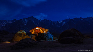
Tired from having driven all day, I slept well through the night, and snapped only one photo before snuggling back down under the covers for another hour of shut-eye as morning broke.
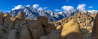
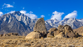
I knew I had a lot to explore - and not all that many daylight hours in the middle of winter - so that last hour of sleep was more like avoidance-of-cold than anything else.  And really, I shouldn't have been all that worried - when I did climb out of the tent, it was actually quite pleasant and the views... well, even with some clouds over the Sierras, they were everything they'd been cracked up to be.


The views weren't the only thing I'd heard about Alabama Hills, however. I'd also heard that they were crowded. Like, crowded. I figured that showing up on a Thursday of a non-holiday week would mean that I'd miss the crowds, but boy was I wrong. Even though I'd come in after 10:00pm the night before, several others had driven by my camp site during the night, and I woke up to another Subaru parked less than 100 feet away! Hmm.
Still not having seen much of the area, I chalked it up to having chosen a place along a reasonably accessible road in the middle of the dark and set about eating breakfast and tearing down camp. By 8:00am I was on the trail, and headed less than a half mile to my first stop of the day - Boot Arch - sunlight highlighting the crumbling granite terrain as I made my way on foot.


Boot Arch easily stood up to its name - the boot clearly of the rock-toed variety. And in what would become my favorite part of Alabama Hills, the arch was framed by the lightly dusted Sierra Mountains in the background.

Happy for the early win, I climbed back in the truck and made my way west along the Alabama Hills Trail, hoping to eventually pop out along Whitney Portal Road - its switchbacks rising up the mountains in the distance.

Alas, I knew this was going to be a bit of a longshot - even as I'd mapped the road during my route planning, there was a section that I was forced to hand draw - though that portion was much further along than where I discovered the road closed sign as I wound into the heart of the granite outcroppings.
Still, I'd had a great time making my way up this fun little road, so after snapping a few photos - I was still trying to learn the new camera setup - I got the Tacoma turned around and headed back out towards Movie Flat Road. Along the way, I was surprised by how many people I passed - several of them seemingly there for various product photo shoots - a woman posing behind a spread of hot sauces the morning sun; a skinny, flannel-clad, heavily bearded dude looking out across the landscape as he climbed into a wedge-shaped tent.
After encountering half a dozen folks on the few-mile stretch back to Movie Flat Road, I was unsurprised to find that the main drag was nearly a highway. Sure, it was dirt, but there was no need to air down - no need in the slightest. Of course, not knowing this, I'd aired down the night before while setting up the tent - and while I hoped it hadn't been a complete waste of time, I took solace in the fact that I got to experience a very plush ride! 
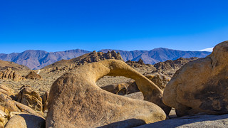
Making my way south now - the Eye of the Alabama Arch caught my eye and I paused for a few shots in different directions, and to capture the Tacoma overlooking the landscape.


From the arch, I continued down into the heart of the region, more and more vehicles dotting the landscape - seemingly every nook and cranny, crammed with a tricked out SUV pulling an overland or teardrop trailer. It was at this point that I realized that after this trip, I probably wouldn't be back any time soon - the crowds more than I can handle when I want to get away.
Side Note: As crowded as Alabama Hills was, I would be remiss not to mention that the BLM has realized this as well, and is taking steps to address it with their Alabama Hills Management Plan. This is a great thing in my opinion - if people can't be respectful, stay on trails, pack it out, and not overrun a place, it's only right to try to protect it. I've read through the plan and it seems more than reasonable, with camping limited by permits and several of the "random roads across the landscape," closed.
But, that didn't mean I wasn't ready to enjoy myself while I was here - and my next order of business was hiking the Arch Loop Trail, which winds its way through a series of short canyons and past a few interesting arches.

Always nice to get out of the truck and walk through the surroundings.

Even in the canyons, views out their openings were enticing.

Mobius Arch.
Another view of the Mobius.
I quite enjoyed the Arch Loop hike. Less than a mile long, I had it to myself since it was still reasonably early in the morning, and being able to poke around by myself was very nice, as I can imagine that this area is usually crawling with people, given its central location and prominent markings along the road.
With my little warm-up hike complete, and the Sierras being the highlight that continually called to me, I decided that my best bet was to duck out of Alabama Hills proper for a few hours, and tackle a nearby hike that I'd found that would lead me up into the hills. It was a bit south of my current position, so that's the direction I headed.
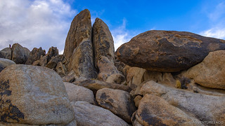
As usual, I was distracted before getting where I was going, as I looked to my west and saw a strikingly shaped rock reaching up into the sky. A sign identified it as Shark's Fin. I got out to take a look.

Perspective made the fin rise higher and higher out of the ground, the closer I got. It was fabulous.

This is apparently - like much of Alabama Hills - a favorite climbing spot for local boulderers, and several anchor lines made their way up the various faces of the fin. It'd have been fun to have a set of ropes and climbing partner to scale this one, I think!
Shark's Fin proved to be my final distraction on the way to the Sierras, the Tacoma eating up the slightly-bumpier Tuttle Creek Road easily, though at this point I was glad to be aired down.

As I gained elevation, I started running into patches of snow. I counted my blessings that I'd made it down for a second trip before a good snowfall rendered the area - both for driving and hiking - impassable.

Then - all of a sudden - boulders across the road, and a sign stating that only foot traffic was allowed beyond this point. I was a good mile - and 700 vertical feet - below where I'd planned for the end of the road to be, adding a nice little chunk of work to what was already going to be quite the trek!
So, I parked in a pull out and gathered up a water bottle (which I forgot to put any water in), my camera, and a sweatshirt. Looking back now, I also should have taken some water, some Yak Trax, and an extra camera battery - but hey, hindsight is 20/20. I set out up the trail, the majority of it covered in icy snow from the get-go!
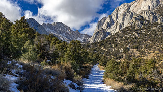
At this point, I should probably mention where I was going... I was going to the Tuttle Creek Ashram, a structure I'd found a couple miles up into the Sierras, along Tuttle Creek. This wouldn't have been an easy hike dry, and the slippery ice made it rather treacherous. Eventually I finally saw the Ashram in the distance, and I hoped it was all worth it!

Can you see it? It's well camouflaged!
Situated at an altitude of 7,600' between the north and south forks of Tuttle Creek, the 2000 sqft ashram is built in the shape of a balanced cross. Constructed of natural stone and concrete, it has a a cement floor, heavy-beam roof, large fireplace, and raised alter.

Originally envisioned by Franklin Merrell-Wolff and his wife Sherifa when they first visited the area west of Lone Pine, California in 1929, it took ten years for construction of the ashram to begin. When it finally did, Wolff handled all of the dynamite used to blast a flat area, and as rock began piling up, he got the idea to use it in the construction of the building. Over the course of another decade, he and his Assembly of Man built the ashram along the four cardinal points of the compass, their days full of hard labor; their nights filled with music and study around the fire. Eventually, stonework walls, a large stone fireplace, two intersecting heavy-beamed gable roofs, and the window and door casings were all completed. But in 1951, before the windows and doors were installed, work ceased on when Sherifa was no longer able to make the trip up to the building site.
After Congress passed the Wilderness Act in 1964, Tuttle Creek Canyon became part of the John Muir Wilderness, and the Forest Service terminated Wolff's special use permit. In 1980, it was considered for historical significance and over the next twenty years, there was consideration of adding it to the National Register of Historic Places. These plans were never culminated, leaving the ashram somewhat in limbo to this day. (merrell-wolff.org/ashrama)

Never completed, the inside is remarkably bare.

Originally, there was no inscription on the altar, but sometime in the 1960s, a visitor chiseled words into the top face.

Definitely prime location.
After spending twenty minutes or so poking around the old site, my grumbling stomach and empty water bottle urged me to head back down the hill. There, I'd fire up the grill for some hot dogs - an unusual, warm lunch - my idea on this trip to do any cooking during the day so that I wouldn't have to freeze while I made dinner at night.

I'm not sure cooking for lunch was really the best idea - it took way longer than making a sandwich, and it was time I felt would have been better spent looking around - in the daylight. Because, while cooking dinner in the cold may not be terribly fun, at least it takes place in the dark! But, whatever - the hot dogs tasted fabulous, as did a nice long swig of cool water, and before long I was headed back towards Owens Valley, thankful for the beautiful day I was having.


At this point, it was still only 3:00pm - a good couple hours until sunset. Clouds were starting to roll in over the mountains, but I figured that I could drive through the various rock mounds that comprise Alabama Hills before finding a spot to set up camp for the evening. I'd mapped out a route that looked interesting - a couple arches and nice views noted here and there - but only roughly followed it as I wound my way around the area.

Interesting erosion.

Taco Bell Arch.

Wind weathered.

Hitching Post Arch.
As I wound my way through, I oscillated between joy and worry. There was so much to see - rocks that called to me to get out and scramble amongst their forms, arches begging to be peered through from different angles. At the same time, I couldn't help but notice that more and more people were arriving. Camp spots were quickly filling up. If I kept exploring, would it cost me a private spot in which to stay the night?
In the end, I reminded myself that I was here to enjoy all that there was to see. I'd known beforehand that it could be busy, and I knew that even if it wasn't ideal, I'd definitely be able to find a spot to camp - so I just took my time and explored. There really are some beautiful sights throughout the hills, and I'm sure I only scratched the surface.


The trails through it all were well worn, and easily passable in all spots but one. Here, a tight turn through some narrow rocks, with the trail dug out from tire spin - a bit of skill and 4wd were required. And, I could tell it was much less travelled than the rest of the road, because someone had setup camp just to one side - and they were quite clearly surprised to see anyone come from the direction I approached!

Even exploring most of the trails south of Movie Flat Road, it was still a little before 4:30pm when I felt like I'd seen what I'd hoped to see, and retraced my steps to a spot I'd noticed along the way that afforded a nice view and shelter from the northwest winds that were picking up steam as they blew a cold squall over the snowy Sierras.

I spent the next hour hopping around the boulders that surrounded my camp. I wasn't doing any real climbing per-se, but there were so many nooks and crannies to look in and scamper through - it was a joy. Eventually, as the sunset approached, I returned to camp and deployed the tent - a job more easily done in daylight - before settling in to read and process a few of the days photos (my first batch with the new camera).

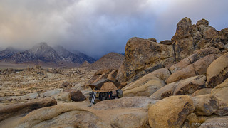
Sunset itself was lackluster - the sky mostly overcast, reducing the sun's ability to stream long rays of light along all but a few high clouds.

Not wanting to go to sleep too early - though, is there really such a thing? - I tried to stay awake as long as I could. My mistake was reading - an activity that can put me to sleep under nearly any condition, much less when I'm still tired from a 19-hour drive!
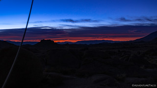
And so, at 7:30pm, I climbed out of the cab one last time to snap one last photo. The skies had cleared somewhat, and I crossed my fingers that they'd stay that way for the next few days.

Little did I realize that the state of the skies wouldn't much matter where I was going. Because who cares, if you can't see it - amIright?
The Whole Story


Love Owens Valley? Check out
Owens Valley
for all the amazing places I've been in and around this special place over the years.
Love your stories and pics but I feel for you having 19 hour drives to get to your beloved desert! You really need to move to the Owens valley. Think of how much you could experience if you had the 38 hours to and from driving time to spend exploring this amazing region. Im sure youve pondered that often given all your windshield time and your truck would love you too!
Bummer about camera and hope new one is better. Keep up the great work.
Like to grab some lunch and visit for a bit on some future trip thru Bishop.
I have a Tacoma as well and love to see how you've outfitted yours.
Safe travels, Greg
Thanks Greg, glad you're enjoying as always! Boy, the drives aren't great, but I take solace in the fact that I will eventually move closer (I have a plan, and even a place to live, but it's a few years away), because you are 100% correct in the "think of what you could do with those 38 hours," observation!
One thing I've considered - actually, I would have done it last year and this year, but had to put it off until next year - is renting a space for the truck in Las Vegas and flying home "between trips." That would make travel time much less, cost only a little bit more, and save tons of wear on the Tacoma. So, I can't wait for winter '21-'22 and my vaccine!
Would definitely be cool to grab lunch sometime. I've heard great things about the BBQ there at the north end of town, and of course Schats is tasty as well. ?
Yeah, that area can get packed, so we usually go during the week in the off season and trade cold for less folks. With a little looking around, we've been able to find some cool spots by ourselves. It's still a great getaway for a couple days with unreal views.
Yeah, I was there on a Thursday night in January (which seems like the off season to me), and it was super packed. I think this year is just more crowded than most. The views are great, and there are so many nooks and crannies to look around, Sierras are so close, it's great! ?
camera to see difference? also maybe take a pic of your equipment for taking pics?
Last lets see a map of the route so I can consider the same trip? Its nice you travel as single tacoma--most other are in convoy for saftey. I want to go as single jeep and you have previewed the trail for us.A map of each trip would be great--
thanks
mark
Hey Mark, I'm glad you are enjoying the stories. I'm not sure I totally understand your questions about the camera - can you ask them again?
As far as maps go - I don't share GPS tracks for a lot of reasons, but if you have a map and put pins in as I name place in a story (roads, landmarks, etc.) you can pretty easily recreate my routes. I've also put together this series on route planning, which can help you put together a route for yourself!
On cameras- I would like to see the same shot taken at the same time using an expensive and cheaper to-cheap camera. Are your pictures edited a lot to enhance? or is it just a good camera?
On Mapping --how about a minimalist approach showing general are to see what part of the state we are in for us in midwest who do not recognize any of the names you use?
mark
Hi Mark, Ahh, I understand the camera questions better now. If I were doing a camera review site, I might spend more time comparing shots from various cameras, but since I'm just telling stories (and include photos) I don't really want to get bogged down in the details of "one camera vs. another." I did however put together this post about how I take photos and the systems I use. Once you move up to a dSLR, there's definitely editing involved - unlike a point and shoot or phone - in order to get something that's even usable. That's because RAW photos are just a different beast than the JPGs out of the more "consumer-y" (not to imply that they are bad) devices.
As far as mapping goes, that's an interesting idea. I always figured that it wasn't too hard to type the name of the place into Google - like Alabama Hills, but I can see your point. Thanks for the suggestion! ?