
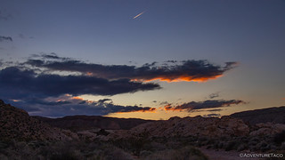
While camping in a wash less than 12 hours after the national weather service issued a series of storm warnings for the area may seem foolish to any normal person, it actually turned out to be one of our most pleasant nights of the trip.


Of course, I was reasonably confident that was to be the case when we setup camp - this wash didn't appear to have had much in the way of water as we'd hiked it the previous evening, and we were several feet from its low point should water have started to flow.

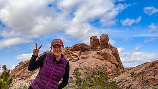
The trailhead we'd camped at wasn't far from our first hike of the day, and with the tent now fully dry, it was a quick operation to stow it away while @mrs.turbodb made breakfast and packed up the rest of the truck. A little after 7:00am, we were on our way, the sun at our backs, illuminating the red hills to our west as we set off towards Black Butte Rd.

I'm sure the truck had warmed up by the time we arrived at the trailhead to the Kohta Circus petroglyphs, but probably not for long. Located around the south side of Black Butte, this was the hike I was most looking forward to prior to making the 20-hour drive south. Or maybe the second most. 
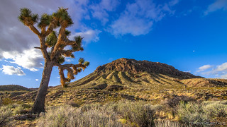
We set out through the desert, our trek south departing from the colorfully decorated side of Black Butte - weaving in and out of various washes, up and over various alluvial fans. Through a Joshua Tree forest, and past long-abandoned fire rings and camp sites.

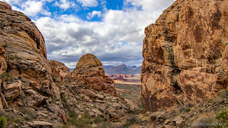
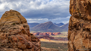
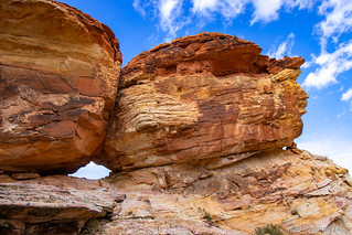
As we did, the views in the distance were as dramatic as our immediate surroundings - dark mountains on the horizon, shaded by the clouds above; sunlight streaming through from time to time, illuminating the brilliant geology rising up out of the Mojave's desert floor.


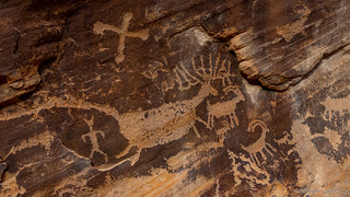
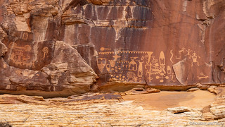
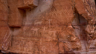
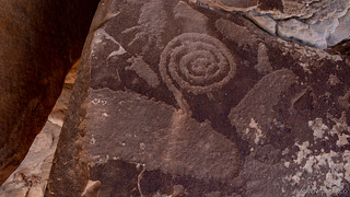
After two miles of early-morning enjoyment, we found ourselves descending into the maze of canyons protecting the panels that make up Kohta Circus. There are several distinct panels at this site, and we started at the lowest of them. Approximately 80 feet long, it contains so many figures that it took us 15 minutes to just make our first path along its entire length. I wouldn't use the word cluttered to describe it, but I wouldn't fault you if you did!


This is the panel that gives Kohta Circus it's name, presumably due to the large number of animals that are depicted along it's length. It's tucked along the southern wall and the petroglyphs are at a height comfortable for viewing along its entire length. I did my best to capture the entire length of the panel, but in the end, anything longer than about a third of the panel got too small in a panorama to shine through online. The story appears to show a migration, with bighorn sheep and many other animals moving to the right on the top portion of the panel, and then to the left along the bottom. In many places, the animals are connected from head to tail with lines - perhaps lead lines to keep the group together. Many other symbols also come into play at various points throughout the story, indicating that they are not randomly placed, but have a deeper meaning that has been lost to time.

And, a few of my favorite glyphs...

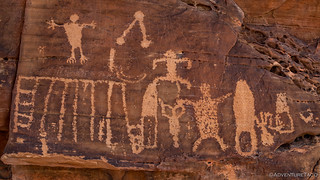
Man shooting a bighorn sheep.
Unlike the majority of animals, this was the only deer/elk depicted in the panel.

A few of the dozens of sheep moving in a line.

Turtle.
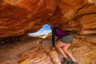
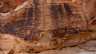
As we'd come into the canyon, I'd already spotted the upper panel on the western wall - and it was dramatic. Poised 80 feet up, it was high off the canyon floor and difficult - if not impossible at this point - to access. This of course was a good thing in our minds, since it would keep people away and help to protect the glyphs. This was my favorite panel of all that we'd see the entire trip, and I wasted no time doing my best to capture it from several angles. None of them seem to capture its magic entirely, perhaps due to a lack of scale, or because part of the magic is physically being in such a special place.

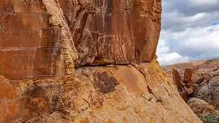
Getting some of these angles required a bit of climbing, and in doing so we continued to uncover even more of the artwork that adorned the canyon walls. And, while much of the art has survived nearly unaffected by time, there were a few places where we could see slabs of sandstone that had sheared off in the middle of a panel.


Having drug out our exploration as long as we felt we could, it was time to head back to the Tacoma and on to our next stop. Hoping to make the hike into a lollipop-shaped loop, we followed the wash containing the glyphs as it made its way up-canyon. We didn't know if the route would be passable, but even if it wasn't, it was sure to be a beautiful extension to the hike so far.

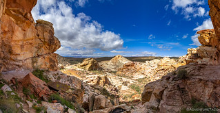
After a mile of following game trails up the canyon, we finally came to the constriction of the walls. Luckily, this wasn't an impassable dry fall, and with a little scramble we found ourselves on the upper plateau that we'd hiked out to the Circus an hour before.

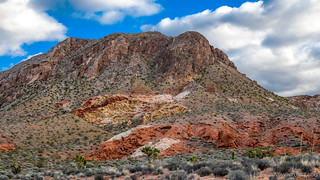
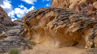
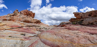
Even the hike back was enjoyable, the views now different from our new direction. The geology here really is amazing, the white and red offsetting each other so dramatically everywhere we turned.

We'd gotten an early enough start on our first hike of the day that it was barely 10:00am when we found ourselves back at the truck and headed to our next destination. This section of Gold Butte National Monument is packed with petroglyphs and I had another hike planned - less than five miles away - that I hoped would be nearly as dramatic as the last: the Falling Man petroglyph.
This was a hike that I knew contained more than just a panel or two of rock art - it was an entire trail of various panels and glyphs. Clearly, this was an area that had been inhabited - rather than passed through - by earlier people, and there had been plenty of time to carve intricate stories into the rock. Our first stop however was at a formation known as the rabbit ears, for obvious reasons.
Next was Calvin's Rock. Named for Calvin Meyers - an environmental activist and former Chairman of the Moapa Band of Paiutes - this boulder is literally covered in art, and it's understandable that Calvin had a special connection to this boulder.


From there, we continued on. Walking through a maze of rocks and sandstone crags - the surrounding plateau eroded over thousands or more years - we admired the passage of time witnessed by the vibrant colors exposed over the years, enjoyed by those who left carvings on their surface in the same way we enjoyed them today.

Our wandering eventually led us to a tunnel - not a surprise for me, but something @mrs.turbodb was excited to learn we'd be climbing through, rather than just viewing and moving on!
The view as we emerged on the other side of the tunnel was one of the more dramatic we'd seen, the rainbow of rocks against the bright blue sky, enough to stop both of us in our tracks for a moment.
Through the tunnel, a 10 foot ledge continued around the outcropping, beckoning us forward. I - however - knew we needed to show restraint. Somewhere along this ledge was the namesake for this hike - the Falling Man. Not easily discovered due to its positioning behind and above the adventurous hiker, we eventually found it, the man dramatically contrasted with the weathered rock behind.

It is of course unknown what the story of the man truly represents. Perhaps a memorial to a friend or family member who suffered a tragic accident; or perhaps a simple warning about being careful on the ledge.

One of the great things about this area is that no matter where we turned, we discovered more petroglyphs. Some were in better shape than others, but all of them fun to discover as we scurried over and between the rocks. And adult Easter egg hunt of sorts. 


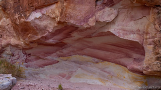
We explored our way through the next quarter mile or so, down past several tinajas - full from the recent rains, and eventually to the next well-known panel in the area - Newspaper Rock. Named for the large collection of petroglyphs on the flat panel, Newspaper Rock stands overlooking the canyon, quite an inspiration for the creators of this massive piece of art.


From Newspaper Rock, our path curved back up and around the next outcropping where several more interesting stories presented themselves. The first was what's known as the Bigfoot - or Hang-Ten - glyph. Carved into a flat boulder that's broken off of the overhang above, the namesake was too big to fit on the surface, the toes wrapping around the edge of the rock, as though hanging ten on a surf board.
Then, another big foot and one of my favorite - I'm not sure why - carvings: man-with-two-slingshots-at-waters-edge.

Finally, we made our way around to the back side of the outcropping to discover two more enormous panels - one above the other. Like the upper panels at Kohta Circus, these were high above the nearest flat surface, suggesting that whoever developed the carvings must have done so using some sort of apparatus. These too contained some of my favorite petroglyphs so far in the trip, once again well preserved by their inaccessibility!

Look closely for the upper and lower panels here.

Upper panel detail - one of my favorite.
More from the upper panel, a ladder and scaffolding depicting the apparatus used to create these works?
The lower panel, weathered over time and yet still the figures, geometric shapes, and patterns vibrant to this day.
We'd spent another two-and-a-half hours wandering around this amazing site and only our grumbling tummies pulled us back to the truck just before 1:00pm. There, we broke out the fixings for turkey sandwiches, chips, and some of the best Cosmic Crisp apples (try them if you haven't!), which we enjoyed in the truck's shade by the side of the road before retracing our path north on Black Butte road towards Whitney Pockets.

It had been short, but our time at Gold Butte National Monument was over - at least for this trip. I'm sure however that we'll be back - this place is quite obviously another - if slightly smaller - Death Valley type location for me. By that, I mean that I planned my first visit to be my last, but quickly realized that I've only scratched the surface. As with Death Valley, there is much to see in Gold Butte National Monument, the best of which is likely hard to find without some inside knowledge and tips!
We had one more stop to make as we exited the monument the way we'd entered - something that was especially intriguing to @mrs.turbodb who is a pop culture fanatic - the Bundy Ranch. This is where the standoff between the wacko Cliven Bundy and the BLM took place in 2014 when Bundy refused to pay his grazing fees and lost countless court battles. While perhaps interesting in itself, the Bundy's were even more interesting to us, since we'd visited the Malheur National Wildlife Refuge shortly after it was reopened after the Bundy's occupied it in 2016 in another display of dumbassedness.
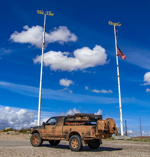
Perhaps unsurprisingly, their ranch was a rundown dump, and their flag was in tatters.

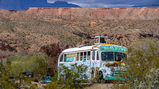
And then, a little way down the road, another strange sight.
It was early afternoon as we aired up our tires - our next destination some two hours to the south and west, in the Valley of Fire State Park.
As the ARB compressor chugged away, we made a decision that would impart a lasting impact on the remainder of our trip. Over the previous few days, news of Covid-19 had continued to snowball, Seattle Public Schools had closed, and ideas as dramatic as closing the borders to Washington state were starting to be floated. Airlines, rightly understanding that people shouldn't be - and were afraid to be - flying were allowing cancellations with no charge.
Our plan - as regular readers may recall - was to fly home in the middle of the following week - leaving the truck with Brent @PcBuilder14 in Las Vegas - flying back a week later for another several days of adventure. But, with all the news, we began to wonder if flying back would even be an option. If airlines stopped flying - or if borders were closed - would we be stuck at home without the Tacoma?
In the end, we made the tough call to cancel our flight home and thereby cancel the second leg of our adventure - for now though, we'd continue to explore. We had lots to see in the next 24 hours - at which point we'd head north, making it home by the time our flight would have landed. The decision was both a bummer and a relief - especially for @mrs.turbodb - and with the logistics taken care of, we soon pulled into the Nevada's Valley of Fire - because with a name like that, how could we pass it by?

")


Holy Petroglyps!!! That's so cool.
They totally were! Not the last we'd see either, though perhaps my favorite. Lots of good stuff to come on the trip though 😉
As usual, your graphic-story is wonderful! Thanks for the pictures!
Thanks Norm, always great when someone enjoys the story and photos. We were lucky to find these - definitely the best that I think I've seen to date.
Awesome Dan! Man do I need to get some miles in and explore down south!! The daughter was supposed to fly to California at the start of all this, we cancelled the ticket, as we didn't really want our 14 year old trapped on the other side of a potentially closed international border. I'm glad we did, even tho I know now she would have been able to get home, I'm glad we avoided the stress of that!