
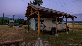
As wonderful as it was to be able to stop by and see my uncle on the outskirts of Quincy, neither of us slept very well through the night. It wasn't the temperatures - though they were warm - or the positioning of the Tacoma - which was nice and flat on the lawn; it was the noise. I think our bodies were looking forward to the quiet of sleeping in the forest, and rebelled at the sounds of civilization that echoed, even from this small town.
Knowing we had a lot of ground to cover, we were up before sunrise. As with the previous day - not that it'd helped then - we skipped breakfast for the time being, quietly stowing the tent and pulling out right around 6:00am.
We're not the only ones in the family who like to explore.
Highway 70 - Red Bridge (Section 3)
While the first section we'd run the previous day - to Poker Flat - had taken significantly longer than expected, the same was not the case for section 3. A stage that the Plumas NF BDT teased as "travel[ing] through mixed coniferous forests and features peek-a-boo glimpses of mountains and waterways," was instead, our introductory tour of the Claremont Fire of 2020. Winding our way through nearly 20 miles of blackened forest, we found ourselves at Red Bridge - the end of the stage - in just under an hour!
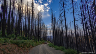
Tall trunks reaching for the sky, a harbinger of what was to come through much of the rest of the day.

The fire hadn't burned along the Middle Fork of the Feather River at Red Bridge, and as the temps began to warm - even this early in the morning - the water looked quite inviting!
Red Bridge - East Quincy (Section 4)
Thrilled to be making such good time, we didn't linger long at Red Bridge before heading back to dirt and onto the fourth stage of the route. Once again, we found ourselves in burned forest as we meandered our way back towards the place we'd started our day!
Thankfully, though the Claremont Fire had scorched this area as well, the fire had been a bit patchier - sparing a patchwork of trees - so we weren't driving through completely monotonous terrain and before long we'd reached the end of the road, just below the summit of Little Volcano.

A short, steep hike delivered us to the top of this little slice of the world.

Little Volcano (also known as Limestone Point) is not a volcano at all, but rather a dolomite outcropping.
After a bit of looking around - and catching our breath - it was back down one mountain, and up towards the next. Ultimately our destination was Claremont Peak, but first we made a stop along the ridge where an old concrete foundation overlooked Quincy. Nestled in American Valley, @mrs.turbodb broke out both breakfast and the binoculars to search for our previous night's camp location as I poked around trying to get a shot of both the foundation and town in the distance.

Breakfast with a view.

Back on the road, a ragged rock outcropping provided visual interest along a burned section of road.

The final push up to Claremont Peak.
The roads in this area have been improved dramatically as a result - I believe - of their use in fighting the Claremont Fire, so while the BDT guide suggested that we might travel at no more than 1MPH through this rocky-with-20%-grade section of trail, we made it without issue in just a few minutes.

Claremont Peak was the site of one of the very first Forest Service lookouts in California when it was completed in June of 1908. By the 1930s, it was no longer used, and no sign of it can be seen today, the site now occupied by a communications tower.
The views from Claremont Peak were nice, but strikingly similar to those we'd had while we'd eaten breakfast, so after a bit of looking around, and some enjoyment of the wildflowers that covered the hillside, we bombed our way towards the end of the stage - in Quincy.
Finally - it seemed - we were making reasonable time!
East Quincy - Spanish Ranch (Section 5)
The only reason we needed to return to Quincy - a mere three hours after our departure - was to fuel up the Tacoma. There aren't many places along the route that have gas - in fact, Quincy is really the only place - so a stop here after stage 4 will be a necessity for most!
Ultimately, it took us about an hour to make the run into town, fuel up, and trace our trail back to the route - but with our early start, it was still only 10:30am!
Now east of Claremont Peak, we were travelling through what would turn out to be some of the last, unburned forest along the entire route. It was an area that'd been spared from the Claremont Fire in 2020, and from the Dixie Fire in 2021.

The vibrant greens, under a partly-cloudy-but-oh-so-blue-sky, were stunning.
A third of the way through this section, we came across an outcropping of Serpentine. California's state rock, this green-hued stone contains heavy metals, so there is often less vegetation around it - though areas of serpentine soil are also home to many rare or endangered wildflowers!

Nice and green.

The contrast between newly exposed and weathered sections of the serpentine.

Gratuitous truck photo. I had my Diode Dynamics SS3 Pro Fog Lights on while we were driving, for visibility to other vehicles, and I just happened to notice the glow as we were out looking at the serpentine.
Pressing on through the forest, we found ourselves winding through tree tunnels that are so common in our home state of Washington. Naively, we may have even complained about them a little bit, joking that we didn't need to drive a thousand miles for an experience like this. Little did we know how much we'd yearn for the greenery for the remainder of the day.

Umm, OK. Share the road with ATVs and... Caddy's?

Puzzle-bark of a Sugar Pine.

The sinuous bark of a Cedar.
Just after 11:15am, we reached the end of the stage at the Spanish Creek Mines where millions of dollars of gold was extracted in the 1850s. Unfortunately, we'd expected these to be actual mines - well, mine ruins - so you can imagine our surprise when it was simply a plaque that commemorated the existence of mines in the area.

To add insult to injury, the largest mine we'd hoped to see had been covered by a county dump. 
Spanish Ranch - Twain (Section 6)
Finally, we'd reached the section of the route that had us the most excited. Here, we'd pass by a place where I spent many a summer as a kid - playing in a meadow, fishing, helping to build a house, and being subjected to hard labor for - what I know now was - a very good deal for my employer. At the time though, I do have to admit feeling as though I was rich after 12-hours of hot, manual labor.
But first, we had to get there - something that would take us a wee bit longer than we expected.
Our first stop was at Spanish Ranch, where two Mexicans - who we supposed were also technically Spanish at the time - started a horse ranch along the Beckwourth Trail which was later named for them.

Over the years, Spanish Ranch grew and the small community served as the center for pack trains that carried supplies to the outlying mines

The Beckwourth Trail was part of the California Trail system, and it's always fun to read the quotes of the emigrants who travelled along these routes.

Less than a quarter mile up the road was the old Spanish Peak - Meadow Valley Lumber Company, that operated from 1916-1964. I think this building must have been used as some sort of kiln for drying timbers.
After poking around a bit looking for an aerial tramway that had hauled lumber to the mill - but finding nothing - we continued into the mountains, still blissfully unaware that we'd soon find ourselves in the charred remains of the Dixie Fire. It was only as we approached the Bean Hill Mine - an enormous hydraulic mine that covered hundreds of acres of hillside - that the fingers of the fire's edge began to creep across our path.

The sparsity of trees on the colorful tailings - washed from the hillside using hydraulic monitors in the late 1800s - is all that saved them from destruction in the fire.

A bit of chalk graffiti on an old piece of metal piping.

More remnants of the piping used to move water where it was needed to blast away the hillside.
From the Bean Hill Mine, the route almost immediately entered the Dixie Fire burn area. This was a huge bummer, as the next discovery point we planned to visit were the wooden towers of another mill owned by the Meadow Valley Lumber Company. With our fingers crossed, we pushed on - hoping that the fire had spared this historic patch of forest, or that firefighters had been able to save the towers.

With nearly everything burned, our chances to see the 125-year-old tramway towers weren't looking good.

As we feared, the towers had been reduced to piles of metal bits.

Bolts - with square nuts - that once held the beams that supported the inch-thick cabling that hauled the lumber.

A bit disappointed, we continued on our way through the aftermath of the fire.
The following section is a bit off-topic, for which I apologize in advance. My primary audience for these trips is my family, and we're all familiar with this place, so there are some details and inside jokes that not everyone will get. Still, I want to capture as much as I can, since I'm not sure when I'll be back next.
From the hillside above Twain - a place we'd return to in the next few hours, we took a short detour to a nearby valley, and the land on which I'd spent a large percentage of my summers as a kid.
It was clear - even on our way in - that change was afoot. My uncle was always good at forest management - ensuring that undergrowth was cleared and that fire risks were minimized - but lots recent work was evidenced or still in progress, the tree density now just a fraction of what it had been even just a couple years ago. Luckily, however, it had been spared the devastation that came so close!
And that's not all! The main house - which as a child I helped (or perhaps hindered) the construction of - was undergoing major renovations. A new roof, siding. Interior work. Even a brand new dormer on the second floor.
A ping big tree, standing outside the front door as long as I'd ever been here, had been felled recently.

A completely new dormer!

And scaffolding all around - for the roof and siding.

What is this - spray foam insulation in the basement? Talk about luxury!
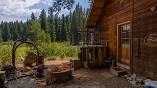
Of course, not everything had changed, and everything was still recognizable - for the most part. Here and there, echo's of the past still grace this fabulous place, and I wandered around taking it all in as @mrs.turbodb prepped another set of tasty sandwiches for us to eat under the shade of a familiar pine.

I've always enjoyed the art on the wall. It has even more meaning now, with all the hunting around for petroglyphs that we've done over the last several years.

A special memorial, standing guard.

Still waiting, ready for the next game.

The browns might be a little leafy, but the cup for the first hole is still under there!

The rest of the course is apparently being remodeled. Perhaps for the introduction of actual greens and fairways. 

Of course, the current resident - and apparently new owner - has good taste in vehicles.
After enjoying our meal - and a quick tour of the fabulously full, lush green garden - we retraced the path of our detour and re-joined the BDT as it continued on to the Butterfly Valley Botanical Area. Unfortunately, the Dixie Fire had ravaged this area, though already there were a few survivors on their way back!

Tiger Lilies are always so bright.

The carnivorous California pitcher plant. This is the reason the botanical area exists.

Around the botanical area, cleanup work was in full swing, hundreds of burn piles formed up on the ground. The question of their eventual ignition, still up in the air.
From the botanical area, it was a simple matter of paralleling highway 70 for a handful of miles as it made its way north towards Twain. Devastation all around us, we realized that even in 102°F heat of the afternoon, it was still much cooler than it'd been when the fire came through.

It was pretty cool to drive through this tunnel under the rail grade, it's not often that we stumble on this sort of thing.

A few minutes later we crossed the North Fork of the Feather River as we entered Twain to complete this section of the BDT.
Twain - Butt Lake and Highway 89 (Section 7)
Today, the town of Twain consists of a post office, general store, a few homes, and lots of recreational camping facilities. As such, there wasn't much for us, and after a quick photo of the general store, we continued on our way - crossing CA-70 and heading up the ridge opposite the one we'd just descended.

As we switched back and forth up a powerline road, a mirror image of our ascent could be seen across the canyon. PG&E recovery work from the Dixie Fire.

Reaching the ridgeline, it was near total devastation as far as we could see. One hillside blackened, the other burned bare.
The entire remainder of the discovery trail would be through burned woods. A hot, dry, dusty afternoon was made even hotter, drier, and dustier given the lack of foliage - a rather unpleasant way to complete what was once a beautiful route.

In addition to the heat and dust, smoke from the 2022 Oak Fire was blowing north - a reminder of the dangerous situation facing forests in the west.

Here and there, a patch of trees survived, and in those short stretches of road, we relished the scenery.
An hour of the dustiest driving I've ever experienced, we were nearing the end of the stage as we came upon two historic sites. The first - Seneca - was originally known as “North Fork” because it sits on the North Fork Feather River, but the name Seneca was given to the mining district in
the 1800s. Besides very rich placer mines in the area, quartz gold veins were also uncovered, leading to a great deal of mining development.

Today, all that remains of Seneca is a single rock dugout, the rest of the ruins having burned in the fire.
The second - the Swiss Mine - was owned by the Piazzoni family, Swiss immigrants who took up mining on Owl Creek. The family married into a local Maidu Indian family and maintained the mine and cabin for more than 100 years. Until two years ago, the USFS preserved the cabin in an arrested state of decay, and we were hopeful that we'd find it saved - either in a green patch of forest, or through the efforts of local firefighters.

Alas, the Swiss Mine Cabin is no more.
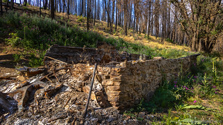
A foundation and some scrap metal are all that remain.

A 170-year-old inscription.

Already, sweet peas were growing out of the ashes and over the foundation wall. In a few years, it'll be hard to find this place.
More than a little bummed, we reflected on the fact that much of the BDT was now inside the boundaries of several fires that have recently consumed hundreds of thousands of acres in Plumas NF. As such, many of the discovery points that were so thoughtfully chosen by the planners are no longer what they once were, and even the route between them itself is a dusty tour of tall, blackened trunks.
While the forest will - hopefully - regrow with time, this may be a route that has its best days behind it. Or perhaps - as with other aspects of the ever-changing landscape, the USFS will adapt the route to the new reality, finding a new, compelling adventure through the woods.
For now though, we put it behind us as Butt Reservoir - the end of the route - came into view. We were in search of a camp site, but soon discovered that the entire shoreline was owned by PG&E, and "No Camping" signs had been posted at regular intervals along the water.

With the evening temperatures still in the mid-90s °F, Butt Reservoir looked like a great place for a dip - if only we were allowed to set up camp.
Instead, we climbed a few miles into the mountains - once again through a charred landscape - until we found a cluster of mostly-still-living trees along a ridge.
As the sun set, we ate dinner and soaked in the skies. I transferred a few photos from the camera to the computer and @mrs.turbodb timed herself at sudoku. Eventually, we climbed into the tent - hoping the temperature would drop enough through the night for us to be comfortable by morning.
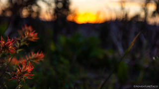
Indian Paintbrush at sunset.
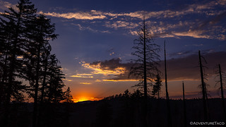
The warm halo of the sun, as the flaming ball begins to release its scorching hold on the landscape.

By the time we were ready for bed, the pinks and purples that we enjoyed so much were fading.
With the Plumas NF BDT behind us, we wondered to each other as our eyelids got heavy - would the Lassen NF BDT be more of the same? We wouldn't have to wait long to find out.

Nice house out in the forest. So, ancient Indians lived in the house and left a petroglyph and they also played golf? LOL. Of course fires are devastating but they clean out for the forest and make for new growth so, eventually, the forest will regrow. Big problem out here is bark beetles that kill huge stands of forest and then the dead trees just stand there waiting for a fire. Thankfully, better forest management is starting to take over to clean out the forests which should also help with fires. As for hydraulic mines, I've never aspired to visiting them since they are mostly destroyed hill/mountain sides and just a big open area. In spite of burned forest I enjoying seeing your journey and may even have to get up the Quincy area one day.
Those ancient Indians never get credit for the robustness of their wooden structures. Of course, people always like to find the stone cliff dwellings, but the real gems are the runs with solar power and running water in the Northern California forests. ?.
I'm with you on the forest management. We still have a ways to go, but in the last several years, we've started to see more and more selective logging (effectively thinning), and there are lots of companies harvesting the standing dead now, which is helpful. Fingers crossed that we can keep improving and end up with a system that will work into the future! That, and we need more rain/snow/moisture!
I've never really experienced hydraulic mines before what with my mine exploration generally being limited to the desert areas (Death Valley, Mojave, etc.) Not much water there, so folks were doing a lot of dry (or very little wet) processing.
As always, glad you enjoyed the journey. The next one is right around the corner!
A nice ride I agree to go through the burned-out forest is somewhat depressing, despite the tranquil beauty of the green forest.
Thanks for sharing!
Thanks Kenny! From here, we're headed north into Lassen NF. The nice thing about that is that the fires have (so far) mostly stayed to the south of where we'll be. So, hopefully it will be a greener (and cooler - temperature wise) experience. Ride safe out there!
Good job, Dan. I learned quite a bit about my own stomping grounds. Of course, I especially enjoyed your recap of the visit to B.V. Your memories brought back some of mine! Wonderful! UJ
Glad you enjoyed it! Nice to see the love going into that place. Perhaps someday, we'll play a final makeshift round of golf, with whatever browns we can find. ?️♂️⛳
Thanks for this excellent report! I travelled part of this route just 6 weeks before the Dixie fire started, so I'm glad I found the log tramway before all that damage.