
The day started out just like any other. Well, any other where the previous included a 12-hour drive from home to the starting point of our next adventure.
So let's back up for a moment... We'd arrived at Bruneau Canyon Overlook just after 10:00pm the day before - our drive from home behind us, capped off by dinner with Ben @m3bassman, Kirsten, Mikey @pizzaviolence, and Amber at their local taco joint - Enrique's - a place they'd recommended a year before when we spent Two-and-a-Half Days in Idaho.
Having grown up in California and with a few great taco trucks at home, I'd have to say it was OK, but not great ( y'all); the company on the other hand was fabulous! And, as we'd parted ways, Mikey had recommended that we spend the night at Bruneau Canyon Overlook - a couple hours closer than we'd planned to camp, and a beautiful spot come morning light. So, as the sun set behind us, that's exactly where we ended up.

And with that, we're all caught up. It's TODAY again!
Our time zones all screwy, it was early - 4:15am or so - when my alarm went off, urging me out of bed to capture the orange on the horizon, an hour or so before the sun would make its appearance for the day.

And then - as has become a habit - I was back to bed The previous day had left me exhausted, and the already warm morning air was such a nice change from the freezing cold that I'm used to waking up to. Soon, I was fast asleep, and nearly 4 hours passed before @mrs.turbodb and I were awoken to the scream of a jet engine and a sonic boom overhead!
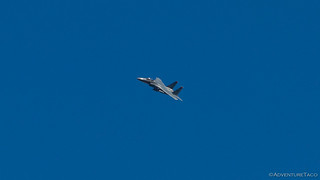

There are few things as exhilarating to me as watching low-flying jets - perhaps an indication that I'm still young at heart - and we watched as 8 jets sped north over our camp site - each and every one doing barrel rolls and having a splendiferous time. Man, how I'd love to get a ride in one of those puppies! And then, as we lay in bed, I looked over and said, "I've got an idea."
Hey! Get. Your. Head. Out. Of. The. Gutter.
See, we'd planned to spend the day heading to Indian Hot Springs via the east entrance - a dirt track that we'd been meaning to take since we'd first come to Idaho 18 months ago to pick up the CBI Outback Bumper. Having run our of time, we'd headed straight down to The Maze, Canyonlands, and we'd never made it back. Then, at dinner the night before, Ben reminded me that he and Kirsten had tried to reach the springs via the west entrance - stymied by a rock slide on the final descent down into the valley.
So I proposed to @mrs.turbodb that we try the west route first. And then, if we couldn't make it down, we'd drive around to the east. But if we could - and if we could ford the Bruneau River (since the bridge over the river had reportedly been out for a few years) - then we could do both sides on our way east towards City of Rocks, our next destination.
My proposal was accepted, and we climbed out of the tent to a hot 75°F morning. And it wasn't even 9:00am yet.

As breakfast was made - homegrown blueberries and Cheerios - I took a few minutes to try (and if we're honest, fail miserably) capturing Bruneau Canyon; what turned out to be a perfect spot to camp for the night.


And then, we headed out - backtracking a few miles to ID-51 where we'd head south, our well-planned trip now "off-the-rails" before we really even started. The best kind of trip - if you ask me. 


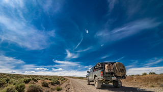
Routeless at this point, we pulled off the highway at a road that looked like it went the direction we needed to go, and set of east - the temperature now already above 80°F, both of us wishing that the AC was in full working order (and a story for another time). But, we couldn't complain about the surroundings - as usual, out here and away from the hustle and bustle of everything else, it was beautiful.


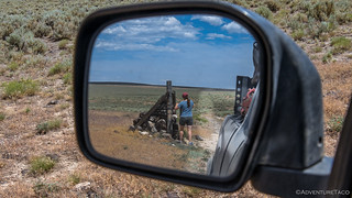
Along the way, we ran into a couple on a side-by-side - out scouting for Elk, the woman having drawn a tag for later in the year. Curious where we were off to, they were surprised to hear of the hot spring and decided it might be just a bit more fun to follow us than continue their scouting mission - a bit of a bummer in our opinion, but who were we to tell them where they could go?
At any rate, ahead of us on the trail, they paused at each fork to see which way we'd go - that is, until the last one where they proceeded left as we went right. Strange, but just fine with us - as we pulled up next to an old rock house at the top of the cherry-stem descent - to an old ghost town located at Indian Hot Springs.


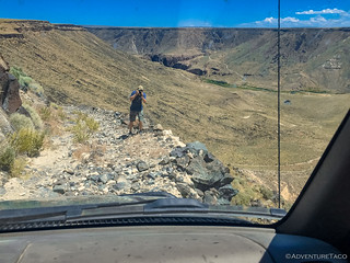
It was here that I decided it would be prudent to walk the trail for a bit before proceeding. This was where Ben had been turned around, and I figured that it was better to find out if the rock slide was still there before we headed down rather than make it half way down, only to have to back up a narrow ledge road. And it was quite the road - only a few inches wider than the Tacoma's track in a few places, eventually making its way down into the valley.


But the slide had been cleared and we slowly made our way down - really only one spot giving me any pause, where the road had washed out on the downhill side. A photo that of course, I neglected to capture!


As we made our way down - uneventfully, though @mrs.turbodb's sweaty palms may have suggested otherwise - I spotted an enormous Great Basin Collard Lizard and popped out to snap a couple photos. This one was even cooler than the one we'd seen in the Alvord Desert just a few months before.


Soon enough, we reached the bottom and it was then that I realized that my initial scouting of the road for descent may not have been as fully thought through as it should have been. After-all, an astute reader may recall that upon reaching the bottom, we knew that we'd be greeted with a bridge that was out, and an uncertain river ford.
If neither of those worked out, we'd need to return the way we'd come - something I'd not been as careful scouting for on my initial pass. And it was quickly clear that neither the bridge, nor the 4+ foot deep water, was going to be our way across the raging Bruneau River.


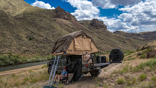
It was lunch time at this point - and hot at 92°F - so before heading back up, we decided that lunch was in order and I unfolded the tent for a bit of shade while @mrs.turbodb constructed some turkey sandwiches for us to enjoy. As it turns out, both of these tasks were made harder by the blazing sun - the ladder for the tent so hot that I had to don gloves to touch it, and the sandwich bread toasted slightly in the few minutes it took to assemble the sandwiches!
But a slight breeze and a view to some pinnacles on the east end of the valley made it nice in the shade as we downed our lunch before checking out what we'd come to see in the first place - the hot springs.


Unfortunately, at 180°F, the hot springs were a bit warm for our taste, so we packed everything up and made our way back up the shelf road, the loose rocks slipping beneath the trucks tires as we hugged the inside line. At the sketchiest spot, a bit more scouting and some spotting by @mrs.turbodb; though of course, it looks tame as can be in a video!

From there, it was clear sailing. We retraced our steps back through the various gates and roads until we reached the highway - the clouds spreading dramatically over a bright blue canvas.

Here, we decided that the 70 miles or so of pavement on our way to the east entrance to Indian Hot Springs was worth airing up, so I pulled out the hose and fired up the ARB CKMA12 compressor to fill the tires - a regular operation that wouldn't be so regular today.
With a bit of traffic passing by, and shortly after starting the first tire, I decided to close the hood of the truck - no need to have every vehicle stop to ask if we were alright. I've done this before and didn't give it a second thought until I was 2 lbs away from finishing the final tire.


Yep, the hose had melted! Something easily fixed in camp later that day, but a reminder that the heat under the hood can get seriously extreme when it's hot out, and both the engine and compressor are chugging away. Keep that hood open, and just let everyone who stops to ask if you're OK, that you are - and thank them for their concern. 
Three of four tires at full pressure (and the last one close enough), we made our way back through Bruneau where we filled up on fuel and started south again along the east side of the canyon - excited again, to explore this alternate path down to Indian Hot Springs.
Mostly. I mean, we were reasonably sure that the sign didn't imply any real danger.

Much of the scenery was similar on this eastern route through this basin and range section of Idaho - the sage-covered plains broken only briefly by canyon walls, as far as the eye can see.


Unlike the western approach, the eastern route to Indian Hot Springs features a few gems to stop and enjoy along the route. It's a good thing too, because the road is - except for the descent into the canyon - significantly worse*, and twice as long.
* Though the "flat" part of the road is in worse condition, if you're squeamish or at all hesitant with your driving skills, the east entrance is safer, and perhaps the more passable route due to the canyon descent.
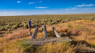
Our first discovery was an old loading dock. Whether for cattle or some other cargo we had no idea - but it was nice to speculate as we checked it out.

It was 8:00pm by the time we started down into the canyon - once again along a cherry-stem road towards and Indian Hot Springs for the second time in one day. This descent was much easier than the west side - the road in better condition, and much less steep as it made its way down.


Two thirds of the way down, our next two gems. Well, only one literal gem - Jasper to be specific. Turns out that:
Jasper was a favorite gemstone in ancient times and is referenced in Greek, Hebrew, Persian, Latin, and Assyrian literature … Bruneau Jasper is a highly-prized and sought-after Jasper variety. Unfortunately it is becoming increasingly rare, which will inevitably cause prices to rise. The sole source of Bruneau Jasper can be found in Bruneau Canyon in Owyhee county, south-central Idaho.-GemTradeNet
This Jasper is a result of where we now found ourselves - at the very center of a “supervolcano,” the Bruneau-Jarbidge caldera, which sent pyroclastic flows a hundred miles and ash a thousand miles across the Great Plains, notably to Nebraska where hundreds of large animals are preserved under two meters of Bruneau-Jarbidge ash at the Ashfall Fossil Beds. (wikipedia)
Now reasonably rare, we didn't find any Jasper, but we did find a well-preserved Chevy truck that old-time miners had used to power some of their mining equipment. The bed of the truck had been converted - a second transmission added - to power a second rear axle, likely used to turn straps/belts that would then power various pumps and sifting machines.


And with that, we reached the bottom of the canyon - strikingly beautiful in the evening light - the perfect place (except for the mosquitoes!) to camp for the night.

Of course, we couldn't do that before we positioned the truck. It'd taken us 7 hours, but we'd finally gotten across the bridge. hahahahahaha

As the sun set, we setup our chairs, @mrs.turbodb got dinner (freshly grilled cheeseburgers) prepared, and I got the tent deployed. For a few minutes, a nice evening breeze kept the blood-sucking-terrorists at bay, but we were right in the middle of dinner when our natural repellent suddenly disappeared, and we were forced to quickly wrap up our meal and retreat to the tent.

That was fine with us though - we'd had a long, hot, fun day, and within minutes we were out cold, the river below providing a relaxing white noise as it rushed down the canyon. Plus, it was only the first day in what would be a week of Idaho adventures.
The Whole Story


Interesting road trip indeed! I was reading about the Bruneau-Jarbidge caldera https://www.idahogeology.org/product/B-26 (p251) and wanted to get a look at some of the landscape and found your article via Google Maps. Great photoessay... and now I know what to expect if I ever visit the area and want to take one of those *brutal* back roads. Thanks for posting this... and "may the road rise up to meet you" on your next adventure!
Awesome, glad you found the stories, and enjoyed them! It's great out there in the Bruneau-Jarbidge caldera and so much to explore!
Wow! What a drive to get to the same place! I drove across that bridge in the early 2000's with my Jeep Cherokee. I also drove down the west side in the late 90's pulling a small trailer. Since I heard they installed a new bridge, I have routed this road for a trip later this year if all goes well.
I visited the area again 3 years ago, in the same Jeep Cherokee. That was the first time in for nearly 20 years. We came in on the east side, but took a bit different route than you did. You may want to check it out for future reference. Look up Winter Wonderland II. George.
Nice, I will certainly check it out! Always looking for new routes in the area.
I've been down since the new bridge was put in - not long after, in fact. We went down the west side (since it's more interesting from a drive perspective) and I was blown away by the quality of the work crossing the river. Most definitely makes the place more accessible - a good and bad thing IMO.
I had heard there was a bridge installed and then I saw a drone shot from a distance that confirmed it. As soon as I saw your Tacoma parked on it, I knew it was the new bridge there. I have not read that section yet. It is weird that they would take the effort to make such a nice bridge in the middle of nowhere.
There are the names of several cattle ranchers on the bridge. I presume got together and went in on it together? It was a very nice looking bridge!
I think you're exactly right on how that bridge was built - it must make it so much easier for the ranchers to move equipment back and forth across the river. All the ranches there (or many of them) are under the same owner (or at least, many had the "JS" markings on their entrance signs) so I suppose it was a joint decision/expense. Definitely a robust structure, and one that will last a lot longer than the original. ?
I will have to check it out when I am down there next month. We are heading down that way for leg 1 of my Idaho west/east route that I am trying to put together. My understanding JR Simplot (Company) asked BLM to be allowed to build a bridge there. Yes, to allow easier access for moving livestock in the area.
Ahh, yes, I bet that's what the "JS" is for, J Simplot. I think I might have figured that out when I was down there the last time as well, but had forgotten, thanks for the reminder!
I didn't realize this comment was on my original story of getting down to Indian Hot Springs from both sides, but here are photos of the new bridge: The Long Road to Silver City, Wickahoney, & Indian Hot Springs | Owyhee Redux #4.
I think your pictures where the first up close shots that I saw of the bridge. I had heard that the bridge was replaced just shortly after I had been down there. I too though I'll believe it when I see it. Happened upon a YouTube channel that basically just flew drones around in interesting places. He happened to be flying around one of the side canyons near the bridge and I saw it in a short glimps as we was making a banking turn back into the canyon. Certainly is a small world.
I didn't realize this comment was on my original story of getting down to Indian Hot Springs from both sides, but here are photos of the new bridge along with the names (and the JS is definitely for Simplot): The Long Road to Silver City, Wickahoney, & Indian Hot Springs | Owyhee Redux #4.