
We were all pretty tired after our long drives south, so once we finally headed to bed - some six hours or so after firing up Mike @Digiratus propane fire ring - I think we all slept quite well through the night; our little spot in Hidden Valley out of the way enough that no one passed by while we were there.
As usual, I set my alarm for too-early-o'clock in the morning and made my way back up and into the Lost Burro Mine site to capture the color as it crept into the sky. It would be our only real sunrise of the trip - other mornings being overcast or our camp sites limiting the views to the east, so I really enjoyed the sunrise this morning.

The most saturated colors are before the sun ever breaks the horizon.

I would later tell the rest of the crew, "I've never followed that road before."

Looking light a beautiful day; blue skies and not too hazy.

The light on the spokes of this belt-driven wheel caught my eye as I poked around the old mill at the Lost Burro Mine.

Just before the sun crested the horizon, light pinks filled the sky behind the mill.
After poking around, I headed back to camp for a bit - to make sure that Monte @Blackdawg, Zane @Speedytech7, and Mike were all making their way out of bed - and poured myself a big bowl of cereal as I watched the sun creep quickly over the horizon. I don't know why, but both the sun and moon always seems to move faster when in their first few - and final - minutes, probably just due to the frame of reference that the foreground provides.
After finishing breakfast and packing up camp, it looked like I'd have a few more minutes, so I was right back to the mine site to poke around with a bit more light. Zane - always the first ready to go - also looked around a bit while the rest of camp was stowed by our companions.

The old cabin, slowly deteriorating over time; now supported by diagonal bracing.

A dugout, originally used for cool storage.

An original chair, or one brought by a more recent visitor?

Up the hillside a way, I found an old shaft that I didn't recall being open the last time I'd visited the Lost Burro Mine.

A maze of passageways; none too deep.
Zane and I didn't linger long - Mike and Monte weren't that far from being packed, and we had enough ground to cover that I'd already forced everyone out of bed earlier than they'd have preferred - before heading back to camp. There, we found Mike ready to go, and Monte on his back under his truck. As is often the case, he'd been working feverishly on his rig prior to departure, and though he assured us that he'd tightened the bolts securing the gas tank skid, it was hanging by fewer than half when it'd been noticed by Zane.

Need a little room to work under a truck? You too can own a one-post rock lift.

Looks factory. (To be fair, this fix held the entire trip.)
A couple of seriously-beefy-zip ties later, and we were ready to roll out of camp and into the morning sun; it was 8:50am. Early compared to our usual trips, but a little later than I'd hoped to leave given the 10 hours of light we were limited to each day.

There's that road again. The one I've never been on. Will need to change that ASAP (but not this trip).

We made good time through Lost Burro Gap as we headed towards Teakettle Junction, the amazing geology of Death Valley reminding us once again why we were here.

There was no hiding where we'd come from, extremely light winds failing to clear much of the dust - even as we spaced ourselves out along the road.
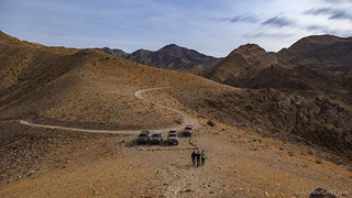
Ten miles and only twenty minutes later, we were at all parked again - this time at the north end of The Racetrack Playa. A curious dry lake - almost a perfect oval in shape - the playa resembles the course for which it was named. The illusion is heightened by the fact that an extraordinary rock formation near it appears to be a grandstand for spectators, though thankfully no vehicles are permitted on its nearly level surface.

Our first excursion onto the smooth surface.
Walking out onto the playa - whether you've done it before, or it is your first time - is always a surreal experience. Distances here - as they are throughout the park - are deceiving, and with only two inches of elevation change over the entire length of the playa, it seems that you could walk forever and never make any progress. Eventually of course, you do - and before long we craned our necks at The Grandstand, as it rose up out of the silty surface.

Mike, contemplating the 73-foot-high outcrop of bedrock.

Scale.
It was fun to watch how everyone approached the rocky outcropping. Zane and Monte went straight to the top - in search of the view from high ground; Mike started a trek around - perhaps curious to capture the rock from various angles; I headed out towards the center of the playa before joining Zane and Monte - hoping to capture the big picture but knowing that it's nearly impossible to do.

King of the hill.

A solitary stroll.
Walking around The Grandstand doesn't take nearly as long as one might imagine, and as Mike rounded the far end, we all climbed down to meet him out on the cracked surface of the playa. Like an endless tray of perfectly-cooked brownies, the playa stretched into the distance, each of the cracks connecting to the next, on into infinity.

Looking south.

As the surface dries, it first cracks along several large lines. Each section then cracks further. Smaller sections continue cracking as the mud dries, resulting in one of the coolest fractal patterns I've ever seen.
Our exploration of the north end of the playa complete, I let it slip - not that I was keeping it a secret - that we were headed to the southern end of the playa in search of the sailing stones. We'd be driving of course, given that it was a couple miles away - or infinitely far if one attempted to walk over the outstretched playa.

Racing along the Racetrack.
For a long time, it was unknown how these rocks moved across the surface. It turns out that they are pushed by wind when The Racetrack is slick with ice, and the trails left by these rocks are eerie. They move in different directions, sometimes 180° to each other, and often with curves in their path.

Where are you going little rock?
Over the course of the next half hour, we wandered - sometimes together, sometimes alone - from rock to rock, each of us discovering the trails and capturing them in our own ways. And, as seems to happen, we eventually all found ourselves together - talking of what we'd seen; looking forward to where we'd go.
And where we'd go was Lippincott Pass. It was 10:45am when we pulled up to the warning sign, and I gave my usual speech: it'd be the most technical trail we'd done so far, but technical was probably a bit of an exaggeration. Lippincott - I've always felt - is more like a bumpy forest service road, especially when headed downhill.

Who needs tow service when you are your own tow service? 

All morning we'd heard jets passing by overhead. As we chatted at the top of Lippincott, Mike happened to look up and catch an F-117 as it streaked north!
I was pretty jazzed to see the F-117, as I've seen plenty of F-18 and F-15s, but never a wedge-shaped silhouette roaring across the sky. And so, a smile on our faces, we started down the pass.
The best part of Lippincott Pass - in my opinion - isn't the road itself, but are the views of Saline Valley that open up as you make your way down the trail. There are few really nice spots to get out an enjoy these views, and we certainly did.

The almost complete lack of wind made for one of the clearest days I've experienced in Death Valley, and for spectacular views.
Back to our trucks, and the windy road out of the mountains.
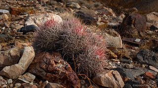
I always love the red on these barrel cactus. And, peering in past the tangle of spikes, I'm always surprised by the bright green!
Switchbacks and short rocky sections continued as we descended toward the southern end of Saline Valley, and everyone had a great time as we made our way to the valley below. It was here - perhaps more than anywhere else so far - that I realized how much I like to be the last truck in the group rather than the first - stopping frequently for photos, never in any sort of rush to stay out ahead.
Although, with all the dust this time, being out ahead had its advantages as well!

New views around every corner.

A few rocks here and there added a bit of interest, but no real difficulty for any of our vehicles.

Lippincott Pass Road drops just over 2,000 feet in just under 5 miles, helped by a series of switchbacks that follow the folds of the Last Chance Range.

My routes have always meant that I've run Lippincott Pass in a downhill direction; eventually, I'd like to drive up, so I approach this cool old National Monument sign from the "correct" direction.

Nearing the bottom.
By the time we reached the bottom and traversed the valley floor on one of the worst sections of road in the park - a straight shot full of football-sized rocks - we were all starting to get a bit hungry. Hoping that the winds remained calm and that we'd get a nicer view, I suggested that we stop in 45 minutes or so, eating lunch at South Pass, overlooking the north end of Panamint Valley.

Zane and his nearly-stock Land Cruiser had the most comfortable ride of the group as we climbed South Pass.
We never made it that 45 minutes - at least, not uneventfully. It was just as we were exiting Saline Valley - and starting the climb toward South Pass - that I heard Mike over the radio, "Oh awesome, look at that!" I had no idea what he was talking about, but figured that it must have been something to do with his - or Monte's - truck. But then, I heard it - just as Monte exclaimed, "Holy shit!" - and seconds later, a C-17 Transport when tearing by overhead, less than 1,000 feet off the ground.
Buzzed by a C-17!
After seeing the F-117 Stealth Fighter earlier in the day, it was a huge treat to be buzzed by the transport, and something we all continued to talk about on our radios - hoping another would come flying through - as we covered the last several miles to the saddle at South Pass. There, with a fantastic view of the Panamint Valley and dunes, we assembled sandwiches and pulled up our chairs in the shelter of Zane's truck - the wind at the saddle just enough to add a bit of a chill - to fill our bellies with food and partake in the good company of our friends.

Lunch with a view.
It was a little after 1:15pm when we finally wrapped up lunch and got back onto the trail. In that time, several cars had passed us there on the saddle, all of them headed up Hunter Mountain, none of them paying any attention to the sign warning of waist deep silt and the handful cars that had been rescued over the course of 2021. Hopefully, none of them would suffer a similar fate.
We, on the other hand, were headed the opposite direction - southwest and then south on Saline Valley Road, first to Lee Flat, and ultimately to Panamint Valley, some 4,500' below where we'd eaten lunch. I was looking forward to this section of trail because Monte had mentioned seeing his first Joshua Trees as he made his way south from Montana, and Lee Flat has some of the nicest specimens in the park.

Dramatic Joshua Trees under overcast skies.

Though we could have done with fewer clouds, the wind that blew them over the landscape was a welcome change.
Joshua trees are relatively fast growers, with new trees growing as fast as 3 inches per year during their first 10 years, then slowing to about half that rate - 1.5 inches per year - after that. As the trunk consists of thousands of small fibers rather than annual growth rings, age determination can be difficult, but they tend to live for hundreds to more than a thousand years old, the tallest trees reaching nearly 50 feet in height.

An ancient specimen.
The afternoon getting on - and with fewer than three hours of daylight left - we didn't linger long on Lee Flat, opting instead to press our skinny pedals a few more miles to a funky little cabin just off the side of the main road. Known as the Boxcar cabin, it wasn't ever actually a box car, but its long narrow shape surely contributes to its name. Being our first cabin of the trip, we all hopped out to take a closer look.

One of several "Friends of the..." cabins sprinkled throughout the park.

A welcoming entrance, cognizant of the surrounding vegetation.

Inside, the cabin was well appointed. A radio, board games, and plenty of reading material to keep any visitors occupied for the duration of their stay.

Beautiful painted glass rendition of the cabin.
The cabin explored, we didn't stop again until we reached the first of two fuel stops we had planned for the trip - at Panamint Springs Resort. Fuel prices here - as always - were costly, but without much choice, we all filled up our tanks and continued south toward camp.

While it may be costly, I'm extremely glad that PSR has remained in operation through the difficulties presented by Covid-19.

Still a couple bucks cheaper than fuel in Furnace Creek!

Patiently waiting.
I'd planned for us to camp on a road I'd noticed winding into the Panamint Mountains on my previous trip to the park; at a little over 7,000', it would be our highest elevation camp of the trip. With the sun setting, we had one final stop before setting up camp - a quick visit to the Charcoal Kilns.

Heading up Wildrose Road as the sun - hidden behind clouds most of the day - streamed underneath them an onto the fanglomerate formations that lined the road.

The beehive-shaped kilns are always a sight to behold.
Built in 1877, these kilns supplied fuel for the Modoc mine smelter located 25 miles to the west - a location we'd visited as part of our retracing of the Nadeau Trail almost exactly one year earlier. Each kiln would be loaded with up to 35 cords of wood from the surrounding forests and then lighted. Then, the wood was allowed to burn slowly for at least a week until it turned to charcoal. This charcoal was then shipped to nearby smelters where it would burn hotter and more slowly than wood, powering boilers and smelters that rarely made a return on their investment. It was for this reason - plus the fact that the kilns appetite for wood quickly devastated the surrounding pinyon pine forest - that the kilns operated for less than three years, shutting down in 1890. By that point, the Modoc Mine - which they had supplied - was one of the most successful in the region, delivering more than $1.9M in silver to its owners.

The vents along the lower wall allowed air to flow through the kiln, cooking the wood into charcoal.

On a day I thought we'd be to camp early, our trucks were still lined up at the kilns three minutes after sunset.
Though we were later than I thought we'd be, camp was only a few minutes away, and before long we were all set up with a nice view to the west and plenty of shelter for the cool night ahead. We'd covered a lot of ground - just over 100 miles, through three valleys - and we were well positioned for the next day - a day that I hoped would be a highlight of our trip!
Little did we know - while it would surely be a highlight, it would also signal the beginning of the end.

Light fading from the sky, we'd soon find ourselves seated around a propane campfire - chatting with good friends - late into the night.
The Whole Story


Great trip, I am sure your buddies enjoyed it very much. The photos were excellent as usual. Are the roads open to ATV/UTV travel? This trip and others you post really encourage me to set up a rig.
We did have a great time, and I bet you'd enjoy exploring the area a lot. It's big though - deceivingly so - and so being able to base camp somewhere (or in a few places) for a week or two, and go out on day long excursions is a really great way to see the park.
ATV/UTVs are not allowed on DVNP roads, you need to be in a "traditional" vehicle in order to explore. All roads in the park - regardless of surface condition - are designated as "Highways"
Details are here: PART 4 VEHICLES AND TRAFFIC SAFETY
Great trip! Was just there last March. Buzzed by a C-17 has never happened to me out there, but maybe next time! Guessed you were camping just at the base of Lost Burro in those semi-flat spots about 500 feet from the main structure? Great pics as always!
Those sunrise pictures are outstanding. Those colors are amazing. I always tell myself when photographing sunrises or sunsets you better take the picture when you see it because it will be gone pretty quick .
Never been buzzed by a C-17 but I have had a Black Hawk Helicopter fly by me as I was on a shelf of a narrow dirt road .
We got some kilns like that here in Southern Colorado, They call them coke kilns.
Great photos as usual and enjoy reading about your adventures.
So true! I always end up with a lot of “the same” picture because I’m never sure how the light will be different over time and I never want to miss the perfect light!
Nice story and photos,
The desert is an awesome place to visit.
5.54$ for a gallon of diesel is still about half price than the normal diesel cost in my country 🙂