
Lunch didn't take more than twenty minutes or so - as it turned out, there were lots of gnats in town, so we didn't linger - and soon we were back in the truck and headed east. Well, almost. For five minutes or so we were stopped at the train crossing on the way out of town as an excavator loaded itself onto a train car and then balanced itself between the car and a truck that pulled it off down the tracks. Cool!

"Let me just lift myself up and slide this rail car under my track, please hold."

"This looks safe, let's go."
With that, we really were headed east along Jungo Road, our sights set on a destination far to the south - away from the playa - a ghost town called "Tunnel Camp" in the Seven Troughs Mountains. But, as usual, I'm getting a bit ahead of myself...

Headed east, Old Razorback Mountain (Trego Mountain) rising up before us.
Our route took us south - past Rabbit Hole Spring - a place we'd stop on our way back - and onto the 2077 road before spitting us out an hour or so later on 7 Troughs Road. This part of the route followed the historic Applegate Trail, and @mrs.turbodb had a nice National Historic Trail Interpretive Guide from the NPS that gave us some history as well as information about the various T-rail markers that were posted along the way.

Following the Applegate Trail.
In 1846, fifteen Oregonians from Polk County, including Jesse and Lindsay Applegate, and Levi Scott, established a trail south from the Willamette Valley and east to Fort Hall in present-day Idaho. This route offered emigrants an alternative to the Oregon Trail's northern route down the perilous Columbia River.
The first emigrants to trek the new "Southern Road" left Fort Hall in early August 1846 and arrived in the upper Willamette Valley in November. With Levi Scott acting as wagon trail guide, and Jesse Applegate traveling in advance with a small party to mark the route, the hardy emigrants blazed a wagon trail through nearly 600 miles of wilderness. In later years, this trail served as an important route into Oregon as well as to the northern Sacramento Valley arid northern California's Yreka area. -BLM sign
Having woven our way through the landscape, and after a short stint on the nicely graded 7 Troughs Rd, we turned off onto Tunnel Camp road, where we'd approach the ghost town from the north.

"Hey uhh, don't eat my grass."
A mile or so before we reached Tunnel Camp, I noticed the foundation of a mill on the hillside and we pulled over for a look. Nestled into the mouth of Seven Troughs Canyon, this was once the site of a town named Mazuma - a mining town that was washed away in 1912 by a flash flood that created a 20-foot wall of water that killed 9 victims and ruined the town past the point of repair.

Old mill with a storied past.

The foundation of the mill used local material for aggregate.
Like the surviving residents of Mazuma, we made our way over to Tunnel Camp along the old mining road. There, the first structure that greeted us put a smile on my face - it was a dugout, and for some reason I can't really put my finger on, I really love dugouts.

One of us is napping.

This dugout was a dwelling - not storage - from what I could see on the inside. Probably helped to regulate temperatures, year round.

Not a bad view.
As with many buildings one finds these days, the interior of this dugout was in tough shape. Careless visitors, rodents of all sizes, and the weather take a toll on these structures over the years, and before we know it, there won't be any left. But, until then, I'll continue to enjoy them and the treasures they hold - in this case, a living resident doing its best to keep warm in the afternoon sun.

"I see you."

"You aren't going to eat me, are you?"
One of the larger, darker, blue bellied western fence lizards I've seen, this guy was a foot long and nearly black on top, beating out the specimen from Guru Road earlier in the day by a good 2 inches or so. I chased him around for awhite to get my shots, and then we headed off to explore the rest of the mine camp.
Tunnel Camp was built in 1927 with a bunkhouse, a company store, and a number of very cool looking houses - the roofs curved as opposed to gabled.

Interesting roof style.

More modern visitors have adopted this cabin, apparently.

Mechanicals shop.

Graffiti.

I liked the open/airiness these windows provided.
Two mills were constructed - one 5-stamp, and one ball-and-cyanide - to process ore from the mining operations in the nearby canyons. The plan - and hence name of the camp - was to build a tunnel through the mountain to process ore from the Seven Troughs, Coalition, Fairview, and Mazuma mines, as well as drain them of water that had begun to fill them from below.
Unfortunately, while the mills were erected and operated for a short time at Tunnel Camp, the actual tunnel was never functional. Somehow - since it seems that connecting tunnels are reasonably common in mining - excavation of this one was misaligned and did not connect to the mines it was intended to drain. Oops.
Today, much of the foundation of the old cyanide and stamp mills remain below an iron 5 stamp mill. Around it, several large ore hoppers - which metered ore into the stamp mill for crushing - stand tall on the landscape, ore still remaining to this day.

The stamp mill remains on site to this day.

Five stamps. By Joshua Hendy Machine Works, S.F.
Having parked and then walked around the majority of the camp in order to enjoy it at a more leisurely pace, we contemplated our next move as a UTV approached from the south. We hoped it would simply pass by, but we had no such luck. Happy to keep our distance, we climbed into the truck to drive to the upper level of the tailings pile - letting the UTVers roar around the main area of camp.
We actually got a nice surprise above the tailings pile - a second old dugout! This one was quite large and in great condition on the exterior, though the inside was trashed as per usual. Construction of the dugout appeared to be traditional framing, and then the building was buried.

Note the more traditional roof shape.

The exterior door was barn-style, though it's now laying on the ground. A second interior door swung inward.
And with that, we wrapped up our time at Tunnel Camp - though we did make a short stop at the cemetery, where the nine folks killed in the Mazuma flood were buried, before heading north again towards the Black Rock Desert Playa.

An alternate route north allowed for higher speeds on well graded roads.

Approaching Rabbit Hole Springs.
When I'd planned the trip, I'd thought that we'd spend the night somewhere around Tunnel Camp, but as we'd driven by the Playa earlier in the day, I realized it would be a shame to camp anywhere but on its flat surface. As it was already 4:00pm as we headed back, we were both glad for the fast, smooth surface of 7 Troughs Road and an alternate route back to Rabbit Hole Spring that was in much better condition than the trail we'd followed south. What had taken 90 minutes on the way out, took only 45 on the way back and soon we found ourselves at Rabbit Hole Spring, which is now a series of manmade reservoirs.

Rabbit Hole Spring.
There, two more wild horses were quite skittish as we approached, trotting off to a safe distance before turning around to keep an eye on us as we walked around - checking out the spring, the Applegate Trail T-rail marker, and a small set of ruins of unknown origin.

Black beauty.

Too small for a dwelling; perhaps an old storage building?
Still keen to get back to the playa and with a couple more stops before we'd arrive, we didn't spend much time at the spring before climbing back into the Tacoma and continuing to push north, and then west. Our destination was Trego Hot Spring, but along the way we made a quick pit stop at a T-rail marker that was actually on the old wagon trail, about 75 yards from the modern day Jungo Road.
And I definitely wanted to see the old wagon trail.
If you ignore the modern day (disrespectful) motorcycle tracks, this is the two-track wagon road from the mid-1800s!
Just a mile or two further west, we came to Trego Hot Springs. When we first arrived, we thought the springs were entirely dried up, as what looked like a previously marshy area next to the road - and behind a fence to keep people from driving on it - was little more than yellowing grass and a dried mud surface. However, a bit further up the road we started to see water, and just as we reached the railroad tracks that separate the playa surface from the sagebrush surroundings, there was the spring - alive and well.

The water was only luke warm, though apparently it can sometimes be HOT.

This colorful American Avocet was in breeding plumage!
Besides being only luke warm - perhaps 100°F or so - the Trego springs didn't smell good, and there was plenty of growth in the pools. Even @mrs.turbodb - who is much more likely to want to take a dip than I am - didn't seem real interested this time. So after looking around for a warmer candidate and not finding one, it was back into the Tacoma for the last time - finally making our way out onto the Black Rock Playa - to find camp!

200 square miles of flat.
Unable to resist, we drove around a bit before fining a place "in the middle" to camp. Our first stop should be obvious - the exact spot that is Center Camp for Burning Man. I'm happy to say we found nothing there - not a shred of evidence that each year an entire city sprouts up around this spot - which was great, and a testament to the work that the organizers do to clean up.

This is the spot is where Burning Man happens. I'm happy to report that it looks like every other spot on the playa.
We almost decided to camp at Center Camp, or at the location of the bonfire - both places I'd marked on my GPS - but ultimately decided that somewhere a little more off the beaten path would be preferable. We hadn't seen anyone else around, but figure that if others showed up, they might - as we did - head to this spot, just to check it out.
So, we pointed the truck north and drove at highway speeds for five minutes, to a spot that looked identical to the one we'd left. It was perfect. It was home. I setup the tent.
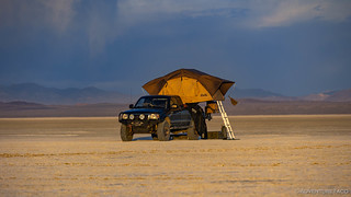
It was windy on the playa - sustained 10-15mph, with gusts to 25mph.
I setup the truck so that it was facing directly into wind, allowing us to make - and eat - dinner on the tailgate with reasonably little concern that things would blow away, or that the stove wouldn't heat things well. Dinner was tacorritos and guacamole - a fan favorite!

As we started kitchen setup, the sun bathed the truck in a sea of orange halo.

A few minutes later, the sun was behind the mountains to the west, layers of land playing across the playa.
Dinner taken care of and everything put away, I think we were both hoping that the wind would die down a bit before we headed to bed. I poked around for a while outside as the light turned from orange to pink and purple, and @mrs.turbodb read her Kindle Paperwhite in the safety of the cab.

Except for the wind, we really couldn't have asked for a better first night experience on the Black Rock Playa.

Last light.
The wind - of course - wasn't going to let up.
Now, I've learned over the years that orientation of the tent makes a big difference as to a reasonable night sleep on a windy night. The worst way to orient is to have the fold-out side of the tent facing into the wind. In this configuration, gusts over about 10mph risk folding the tent up on its occupants.
For a long time, I oriented the tent so the fixed side was facing the wind - presenting the least surface area toward the onslaught, and allowing the wind to blow both over and under the rain fly, with as little resistance as possible. This works - and it's still calm inside with the doors closed - but I've found that gusty conditions seem to "catch" the rain fly, jerking the tent irregularly, making it hard to sleep through the night.
Recently, I've found that orienting the tent so that it is side-on to the wind - with the front of the truck facing into the wind - is even better. This may not seem intuitive as it presents a larger surface area toward the wind, but by doing so, it eliminates the inconsistency of airflow that can catch the rain fly and jerk the tent around. Instead, the pressure is more consistent on one side of the tent, and that consistency goes a long way toward allowing the body to ignore it. At the same time, this method maintains the advantage of not folding the tent up on the occupants, though I still secure the ladder for extra insurance.
Of course, the best solution would be a GFC. Anyone want to start a gofundme? 
Anyway, it was 9:00pm or so when we climbed into bed, earplugs blocking out much of the noise. Reading less than a single chapter on my Kindle, I was asleep within minutes - completely unaware that @mrs.turbodb had once again set her alarm for 4:00am.
But unlike the previous night, a shadow wouldn't keep us in bed this time...


I enjoyed this write up a lot, especially your focus on the decaying shacks and dwellings that someone, a long time ago, made a big effort to build, then partially bury, no doubt to make them more tolerable in the relentless heat of summer and bitter cold of winter. A smart strategy, actually, and a building lesson that we have largely forgotten these days. I love your mixture of wide angle and close up shots of the desert. I was frankly amazed that you could find no trace of Burning Man on the Black Rock Playa. I figured their would be all sorts of scars and debris remaining.
Thanks Mark! Those dugouts are amazing - we tend to find them all over the west, and in addition to the temperature stabilization that you mention, I think that sometimes they even last longer than "traditional" construction because they are sheltered from the elements (mostly wind).
As far as Burning Man goes - we too were surprised, but the more we thought about it, the more we realized that the only way that even is allowed to happen each year (well, sans the COVID cancellations) is that the BLM feels like the organizers clean up well enough that they are allowed to come back. At least, that's where we ended up in our thinking.
Check out OVRLND campers as well. Much more space than a GFC with the vertical walls instead of wedge. Not quite as light as a GFC, but < 300 lbs. They are built very well and the very thick "tent" material is fairly quiet in wind.
Thanks for the tip Ron, I'll check them out! ?
Fantastic overview, as usual, of the Black Rock Desert area. Wondering if you or anyone else has made it back through the High Rock Canyon area that was closed on your trip. I've heard the pin-strip bushes are intense. I got stuck in a huge patch for miles in the Owyhees last fall and it's no fun. How bad is it in the High Rock Canyon? On the other hand, is the there something soooo amazing in the canyon as to make it worth miles of fingers on chalkboards?
Glad you enjoyed the story! I'm sure tons of folks have been through since we were there - it was an annual closure for the animals that use the canyon for reproduction each year.
The sage there was definitely up on the sides of the road, but I don't recall it being all that bad from a pin stripping perspective. Of course, the (narrow) width of my Tacoma generally means that I don't get bitten by the shrubs, whereas newer Tacomas, Jeeps, and certainly full-sized vehicles are sure to get scraped badly!
Where'd you run into pinstriping in Owyhee? Seems like most of what I've run into there hasn't been too bad either...
Thanks. We were in ID, SE of Jordan Valley and headed south west along the northern border of the North Fork Owyhee Wilderness. Things were good all day. We came SE across South Mountain and were trying to head out East through Indian Meadows Spring, but got turned around by a controlled burn in progress. As we made our way back we ran into a section several miles long where the brush had gotten out of control. Would have turned around, but it was getting late and we were 40+mi outside of Jordan Valley, so we powered through to the Owyhee North Fork Campground for the night.
The trail was open and it was definitely worth it. Pinstripe brush was there in abundance, but in my 4Runner we were narrow enough to avoid most all of it. It was a somewhat technical section and could be particularly interesting if there was recent rain. The trail shares the narrow canyon with what looks like a good-sized stream in the wet season. There were maybe half a dozen water crossings. All of them 12" or less in October, but you could clearly see the water could get much higher (although I would guess they close the gates for times like that). We did the canyon starting at the North gate, most of the technical sections and (potentially) bigger water crossings are clustered fairly close to the South end. So if you're in doubt, start in the South and you won't have so far to back track if things get sketchy.
Awesome, glad you had a good time in there! Did you have a chance to check out the (modern) rock art, and visit any of the hot springs in the area?
We had limited time, so had to spend most of our day moving to reach camp. We stumbled on one rock art - a clever shark/whale painted rock up north not too far from Massacre Ranch. We did stop at Double Hot Springs, which was nice . . . too bad it's too hot to relax in. We also rolled past the spring at Black Rock point and saw folks enjoying that one. Downside of that one is it's right on a VERY dusty access trail to the playa, so hope you're alone if you dip in there because 1) there's no privacy and 2) if somebody drives by at any speed other than an absolute crawl, you're going to get a nice moon-dust shower to go with your bath 😉